Watching this soft robot from the folks at DARPA momentarily morphs into something suggesting a domed canopy during its slow and jerky pneumatic migration, surely one can't help but suggest that it should be scaled up, perhaps into something that can accommodate a lecture series event. Flip it over, and you only need water for a swimming pool. Lay it flat, and you've got an outdoor stage or a bouncy playground. Nomadic pop-ups for our biosynthetic future.
But since this post is really a revision of my earlier Soft Pavilions, imagine them at the slightly grander scale of vacation retreats, or more specifically, beachfront McMansions. At the start of summer, or when their multi-billionaire owners and families are en route, a herd of soft robots will emerge from their off-season hibernation in the dunes and crawl out to their lot by the sea. Once there, they fuse together and form a colony of spatial zooids. By regulating the liquids flowing through their built-in hydraulic buttresses, they can adjust their temperature and change colors (ranging from birds-of-paradise flamboyance to tactical camouflage). They can also glow through chemiluminescence.
At the end of the season, these polyps will detach from each other and burrow back into the sand, returning the beach its rolling dunescapes. If a major hurricane is on the way and digging in might not offer enough protection, some may escape into the waters, while others head further inland where they may be corralled into shelters. Returning back to the shore after the storm has passed, they may yet again serve as emergency centers.
You could think of these DARPA biothings as post-natural elaborations of the small dune-sheltered cottages that used to be quite common on coastal lands, particularly on the barrier islands. When needed to be moved, they could be jacked up, rolled on logs, and shipped to the mainland on barges. Considering the all too familiar devastation of Hurricane Sandy and the growing specter of depleted federal funds for reconstruction, this resilient strategy of retreat and settlement should inform any future policy on coastal development.
In the meantime, consider all these Soft Pavilions made not just of silicone but grafted with the muscle cells of rat hearts, perhaps culled from rats captured escaping tunnels flooded by hurricanes. Instead of hibernating in the dunes, these “chimaeric systems of living and non-living components” swim about in the oceans — medusoid McMansions frolicking like a smack of jellyfishes, pumping and flexing to the psychosexual beats of Rachel Armstong, until called up to the surface to make temporary camp.
Replace the cells from rats with that from its morphological kin, the immortal jellyfish, and “[i]t is possible to imagine a distant future in which most other species of life are extinct but the ocean [and coastlines] will consist overwhelmingly of immortal [McMansions], a great gelatin consciousness everlasting.”
To extend our pavilion festival briefly for another day, here some images of the new visitor center for the Giant's Causeway, the famous rock formation and popular tourist destination on the Antrim coast of Northern Ireland. Designed by Heneghan Peng Architects and built to replace the original center which burned down in 2000, it had its grand opening last week.
The usual suspects will no doubt be smitten by its green roof, which helps to seamlessly blend the building into its surroundings. Indeed, the center seems to have just been slipped under a “fold,” incised and lifted slightly off the ground. It's a landform building.
In the words of the architects, “There is no longer a building and landscape but building becomes landscape and the landscape itself remains spectacular and iconic.”
Here's another view of the façade. It has such a gorgeous rhythm to it, a horizon-bound movement that flings visitors out into the cliffsides, farmlands and coastlines. Evoking the towering pillars of the causeway, it also gives this newly reconfigured landscape a nice inner rhyming scheme.
Instead of protecting Japan's coastal cities from tsunamis with massive seawalls, a strategy hardly foolproof as evidenced by the spectacular failure of the country's flood barriers during last year's disaster, why not concentrate all that concrete into tower blocks and resettle everyone on top? Instead of moving to higher grounds, you create higher grounds on the low-lying plains where people are too entrenched to consider a mass exodus.
Most islands will be used for residential purposes, with between 100 and 500 houses and apartments. Fuel stations, waste disposal and storage facilities, and car parks are on lower floors. Commercial islands, meanwhile, will house factories and processing facilities for industries such as fisheries and agriculture. As well as lifting residents high above the destructive power of the waves, the design comes with a number of safety features. A reinforced gate at the back of each island automatically closes after a tsunami warning, while steps up the sides let people climb to safety.
Clusters of these islands could thus form towns and cities.
Of course, one wonders what would happen if an even more devastating tsunami comes along and overtops these islands? Would people finally abandon the coast?
While I normally advocate retreat and throw things at the wall whenever I hear the Army Corps of Engineers and entitled beach resort communities funneling billions of tax dollars into coastal fortifications, I am somewhat beguiled here by the image of these islands growing taller and bulkier every time a tsunami comes along, swelling much higher than the previous one due to accelerated sea level rise, and wipe everything in sight. From their original 3-story heights, they accrete each fresh batch of debris into gigantic stalagmites.
Extending this a bit further, perhaps we could imagine these islands growing still higher, tsunami or no tsunami. People will keep adding more and more elevations, not even stopping when they're safe from the reach of freak megatsunamis. Each new stratum will compel them to lay down a new layer. It's a kind of geo-pathology, incubated over all those decades of disaster-proofing their archipelagos. The islanders won't be able to resist such terraforming compulsion, and in only a few more decades, the coastal landscape of Japan will approximate the karst landscape of Guangxi.
Could these be the future feral descendants of Metabolist towers? Modular units of past and future ruins accreting through a perpetual cycle of destruction and reconstruction.
To alleviate its space problems, the tiny island nation of Singapore has been reclaiming land from the sea since the mid-1960s, expanding its total land area by nearly 25% as a result. And it's still growing.
With no hinterlands to supply it with natural resources, however, it has to import sand, the primary landfill material. But exactly where, the Singaporean government does not disclose. Its supply lines are not public information.
Perhaps partly because of this blackout, reporters from the Associated Press recently tried to track down some of these supply lines. They ended up in Cambodia's Tatai River, where they found “an industrial nightmare” in the middle of “a tropical idyll.”
Lush jungle hills give way to a flotilla of dredgers operating 24 hours a day, scooping up sand and piling it onto ocean-bound barges. The churned-up waters and fuel discharges, villagers say, have decimated the fish so vital to their livelihoods. Riverbanks are beginning to collapse, and the din and pollution are killing a promising ecotourism industry.
The environmental degradation caused by these illegal dredging operations can explain why Singapore is reluctant to reveal its sources. It does not want to be seen as taking advantage of its poorer neighbors or counter its image as a leader in sustainable development.
A few years ago, Singapore's insatiable demand for sand was blamed for the disappearance of some islands and beaches in Indonesia, then a major supplier, which resulted in that country banning sand exports. A decade earlier, Malaysia imposed a similar ban, and last year, it was Vietnam's turn. These bans, however, did not stop the flow of sand from these countries, as an illegal trade flourished. And then there's the secretive police state of Myanmar, which might become a major supplier.
We're inevitably left to wonder if Trevor Paglen or other experimental geographers might want to continue the AP's investigative tour of sand piracy in Southeast Asia, tracing all the dark lines of mineral extractions and trade, starting from erased islands, dying beaches and nightmarish “tropical idylls,” all the way to the strategic sand reserve depots, booming construction sites and artificial islands of Singapore.
Might this dark geography be mapped out like this?
Rietveld Landscape's Interaction between elements is a set of flexible strategies for dealing with sea level rise on Terschelling, one of the West Frisian Islands off the coast of the Netherlands.
The Wadden See and the south side of the Boschplaat [a nature reserve] will grow with the rising of the sea level because of sand replenishments in front of the coast. The northern part of the Boschplaat is unable to grow in this way. There, the existing drift dike will be activated by removing the current vegetation. A huge drifting sand dune will consequently develop. A grid of old mooring bollards ensures that the processes of sand drift and dune formation are readable through time. After years of heightening, a series of perforations in the drift dike is now proposed. These carefully selected perforations will bring about new wash-overs. In this way, an exciting interaction between the power of the seawater, the bollard grid and the dune formation process is created. The Boschplaat will grow with the rising of the sea level and will become ecologically more valuable because of the wash-overs. Both the role of human intervention and the dynamics of the interaction between the elements are made visible by Rietveld Landscape’s design.
Worth comparing this lo-fi accretionary strategy with that of Fabrizio Matillana's parametric Marsh Condenser.
Recycled fishing nets hung between some of the bollards might quicken the pace of dune building.
A co-winner in the Sea Change 2030+ ideas competition, the Embassy of the Drowned Nations is a proposal by the Sydney-based landscape architecture office OCULUS for an inverted Ellis Island sunk in the middle of Sydney Harbour.
Here, in this “blend of Atlantis and Eden,” refugees from former island nations are welcomed and “given the opportunity to grieve, to rest, to recuperate, to learn and to eventually rise up and join Australian society.”
Apart from temporary housing, the embassy will also host a research and cultural center devoted to climate change.
SOAK: Mumbai in the Estuary by Anuradha Mathur and Dilip da Cunha looks at Mumbai’s terrain and the history of its making. It images the sea and the monsoon not as enemies and agents of flood, but as inevitable partners in the shaping of the ground of settlement.
It situates Mumbai in a fluid threshold between land and sea, a shifting saline and fresh water gradient of creeks, and a monsoon surface of holdings. The ground between land and sea is understood to be a filter in section drawings, photographs and models that present this alternative representation of Mumbai’s terrain.
SOAK also showcases design interventions that holds waters rather than channel it out to sea; that work with the gradient of an estuary. It calls for visualizing the city as a fluid field of rain-soaked surfaces, monsoon holdings and overflows, of public-private negotiations.
Rather than fighting the monsoon, it encourages us to design with and enjoy the soak.
*
Here's a brief excerpt from BBC's Coast on artificial coastlines and mobile floating harbours constructed in secret all over Britain for the Normandy invasion.
*
“Sugar Beach is the second urban beach proposed for Toronto’s downtown waterfront, and the latest addition to the amber necklace of Toronto’s lakefront beachscape. It is a sequel to HtO, the waterfront’s first beach park. The proposal for Jarvis Slip playfully recomposes other signature elements of the city, with Toronto playing the role as its own design precedent. The omnipresent horizon of the lake and adjacent industrial buildings recalls Georges Seurat’s Bathers at Asnières (1884). Tinted by sugar spray carried on westerly breezes from the neighboring Redpath Sugar Factory, a series of hard rock candies with colored stripes and dozens of pink umbrellas are scattered across a sandy wedge of beach along the Jarvis Slip. Integrating the future Waterfront Promenade, along with a plaza for programmed and unprogrammed events, the design playfully adopts some of the most enduring elements from Toronto’s emerging landscape identity—beaches, bedrock, trees, and water—as well as the urban horizon and a trace of the city’s past industrial mood.”
*
“Oyster-tecture is a project created for Rising Currents, an exhibition jointly sponsored by the Museum of Modern Art and the PS1 Contemporary Art Center that commissioned design responses to climate change and sea level rise on the NYC waterfront. Our team, led by Kate Orff, participated in an 8-week design and planning workshop at PS1 with a team of local engineers, ecologists, and high school environmental activists to develop the proposal. Inspired by local restoration efforts underway, we propose an offshore wave attenuation oyster-reef and a water-based inland to protect the city’s waterfront from climate changed-induced sea level rise and storm surge. By improving water quality, attenuating waves, and building habitat, Oyster-tecture introduces new strategies for water-based recreation, ecologies, and economies to the residents of New York.”
*
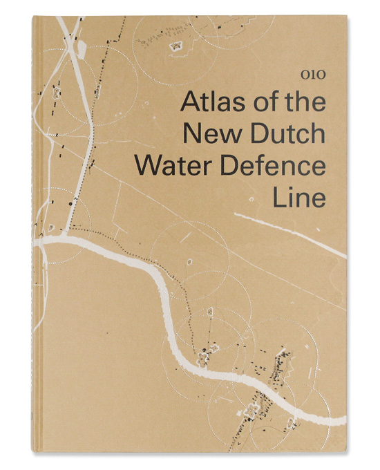
“This atlas addresses the New Dutch Water Defence Line (Nieuwe Hollandse Waterlinie) on a themed basis. Its position in the landscape, the forts, the inundation system, the geomorphology, the strategic system and recent developments can be read off in maps rendered so as to give an understanding of all aspects of the defence line landscape. The defence line reveals itself as a many-tentacled military defensive system of forts, group shelters and polders which can be flooded at the threat of war. The maps show the cohesion of the defence line as a landscape-strategic structure as well as the topographic composition of this structure in layers and components. The more detailed maps of the forts display the wealth of historic places, insertions in the landscape and defining elements.”
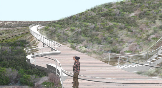
Writes the design team, “Our approach is straight forward incorporating ADA access and providing a safe at-grade crossing. The path follows the topography by tracing desire lines. Existing use patterns are utilized for a minimal footprint of path infrastructure. This strategy encourages ecological restoration, reduces runoff, improves water quality, and provides additional habitat.”
*
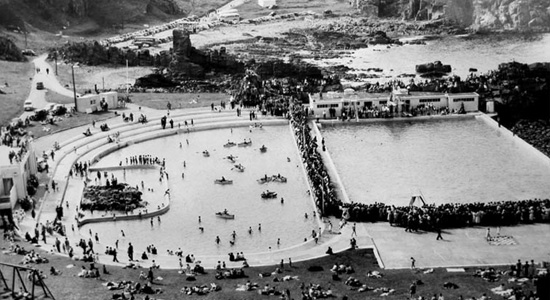
The Tarlair Swimming Pool is a tidal pool cozily tucked into a cove on the northeast coast of Scotland, near Macduff. First opened in the 1930s, it became a popular, even fashionable, social meeting place. During low tides, it provides safe areas for swimming and wading, and at high tides, the sea replenishes its waters by engulfing all areas of the pool. Built in the Art Deco style, its expressive curves, white washed geometric tea pavilion and Suprematist pool stand in awesomely beautiful stark contrast against the craggy landscape.
Tarlair has fallen in disrepair since it was closed in 1995. In 2007, it was awarded A List status, the highest rating, by Historic Scotland in recognition of its “simple yet stylish design, early date and magnificent location.” This status gave the pool legal protection but not immediate funding for restoration.
Here, we're less interested in the Massimo Vitali photograph itself than what it has captured: more or less a construction scaffolding smoothing out a patch of irregular terrain.
Less designery and messier than Vicente Guallart's microcoasts and hexagonal beaches, this seemingly ad hoc intervention creates an occupiable public open space on the rugged coastline of Catania, Sicily, where before only the daring few ventured out. Simultaneously, the structure provides an easy and safe access to the waters of the Mediterranean, an important recreational asset to the local community as well as an obvious exploitable asset for its tourism industry.
We continue our time-saving survey of projects situated on that ambiguous line separating land and water with Fabrizio Matillana's Marsh Condenser, one of the ecoMachines coming out of Claudia Pasquero and Marco Poletto's studio at the AA.
Matillana describes his ecoMachine as “an evolutionary infrastructure situated in the Essex estuary, restoring lost marshland ecologies through a park typology based on sediment collecting ‘folies’ [sic] bridging the dynamic flood cycles of the site and the public that visit the natural reserve.”
These follies act “as a combination of hard and soft engineering technique to increase accretion levels within the test site which is necessary to stabilize marshland in risk. Soft engineering in the sense that it is highly sensitive to its positioning in relation to the environmental dynamics and stresses that contribute to the preservation or destruction of a marshland ecology. Hard engineering in its material presence acting as ‘sediment corset’ and allowing an architectural intervention that embeds itself within the emerging ecology.”
From time to time we'll gather some of the coastal debris that have been cluttering our desktops, bookmarks, inboxes, newsreaders and post queue for months (years, in a few cases), and bundle them together into a single post. It'll be a rush job.
*
The U.S. Geological Survey reviews the proposal to build sand berms along the Louisiana coast to prevent oil from the Deepwater Horizon oil spill from reaching interior marshes.
*
Lebbeus Woods has proposed “the construction of a terrace along the six-kilometers of The Malecón, which is dedicated to public recreation, a type of urban park or abstract beach cantilevered from The Malecón over the sea. Shelter from the sun is built into the layers of each structurally independent terrace segment, which rests on heavy steel hinges such as those used for modern drawbridges. The independent segments can be built one at a time, and also shaped to the curving line of the roadway, so that their ensemble is continuous. Most importantly the segments can be designed to accommodate differing recreational needs along its six-kilometer extent; for example, a set of terrace segments serving one neighborhood could be very open, while another, serving a different neighborhood, could provide more layers of shelter and semi-enclosed spaces.”
“The estuaries of Essex form a liquid edge to the county. This fragile boundary, which extends and retracts with the ebb and flow of the tide, reinforces the connection between the sea and the land. The proposal responds to the current thinking on a managed realignment of the coast, removing hard sea defenses such as sea walls and embankments that prevent the natural landward movement of the salt marshes, and allowing the land to be flooded by the incoming tide. Returning land to salt marsh encourages brackish vegetation and establishes the flood plain as an environmental bugger. A shallow plate is inserted into the intertidal zone, lying low on the horizon. The plate beds into the mud flats, with its extremities in the retreating tide and reaching up to the higher grass land beyond.
“Three territories are formed: oyster lanes fed by nutrient-rich runoff from the salt marsh and high tide, grazing land, and a market. The panorama is framed and partially concealed by the tilted reflected edge to the marketplace, which reaches out endlessly between the sea and sky.”
*
In Turenscape's Qinhuangdao Beach Restoration project, “a heavily eroded, badly abused and decaying beach has been ecologically recovered and successfully transformed into an aethestically pleasing and well-visited place, demonstrating landscape architects can professionally facilitate the initiatives of rebuilding a harmonious relationship between man and nature through ecological design.”