If you enjoyed yesterday's mini film series on topiary robotics, you might also be interested in another line-up on garden machinery presented by Tuinbouw Technisch Atelier BV, a Dutch company (obviously) that advertises itself as “a leading supplier of equipment for handling and selection of young plants and other equipment for growers and industries.” At least for their most recent uploads, the videos are more slick, soundtracked with post-rock, and of higher quality, which make them not at all out of place in a Ron Fricke glorified slideshow, in the them-whacky-humans section.
This is their CombiFix, which is outfitted with a “unique vision selection system.” You can briefly see it from 0:27 reading the electromagnetic spectrum for glitches in these mobile, robot-readable gardens, or at least aberrations according to its programming.
The ways in which ornamental plants, vegetables and fruits have been standardized by way of, among other things, industrial efficiency, institutional regulations, globalization and capricious aesthetics, are endlessly fascinating to think about, so it would definitely be interesting to speculate how such machines and their computer vision will someday affect changes to our ornamentals and food. Will the future orange be redesigned to make it more readable to the LIDAR scanners of fruit-picking machines? Will tomatoes inscribe themselves with vegeglyphs, the agricultural variety of these home “machine-hieroglyphs”?
In any case, here's their FlexPlanter. The video is interrupted by a buyer raving about the machine, how “[b]efore, this process was done by many people” but “now 3 people are sufficient” and perhaps still “two additional persons” can be put out of work. So one second you're in reverie, and the next second you're skirting through issues of weighty importance, like migrant farm labor, immigration and the rural austerity diaspora. (As an aside, the urban youths escaping the econopocalyptic city, searching employment in ancestral farmsteads, only to find them overrun by agrobots, is a story worth fleshing out.)
Of course, I'd like to see these planters go mobile (sentient or simply autonomous), as a kind of Johnny Appleseed peacenik version of DARPA's Big Dog. All day and all night, in landscapes denuded of vegetation by wildfires or some other cataclysmic event, perhaps on extraterrestrial landscapes, they'll be tippity tap tapping seedlings into the earth (or Martian regolith), doubling back once in a while to patch up glitches in the garden.
Previewing an upcoming exhibition co-organized with The Center for Land-Use Interpretation (CLUI), Nicola Twilley, of Edible Geography, takes us on an abbreviated tour of North America's coldscape, the “vast and immeasurable volume of thermally controlled space” that “is as ubiquitous as it is varied.” Exactly how varied? According to her undoubtedly incomplete list for Cabinet Magazine, these spaces of “distributed artificial winter” include shipping containers, floating fish factories, international seed banks, livestock semen storage, cheese caves, banana-ripening rooms and sushi coffins.
These are spaces in which a perpetual winter has distorted or erased seasonality; spaces that are located within an energy-intensive geography of previously unimaginable distance—both mental and physical—between producers and consumers. Artificial refrigeration has reconfigured the contents of our plates and the shape of our cities—it has even contributed to the overthrow of governments, as anyone familiar with the rise and fall of United Fruit can attest. Perhaps most bizarrely, although their variations in form reflect the particular requirements of the perishable product they host, coldspaces have, in turn, redesigned food itself, both in terms of the selective breeding that favors cold-tolerance over taste and the more fundamental transition from food as daily nourishment to food as global commodity.
Information about the CLUI exhibition is, I'm hoping, forthcoming.
For reasons I haven't investigated yet, goats seem to be popular pharm animals. At the University of California at Davis, researchers have genetically modified a herd of goats to produce milk that could greatly enhance one's ability to fight off diarrhea-causing bacteria. At Texas A&M University, meanwhile, researchers are planning to turn goats into malaria vaccine factories. So while some are being corralled as eco-mowers-cum-performance artists into the feral voids of post-econopocalypse cities, these super-goats might someday be saving sick kids.
Perhaps the most famous are the BioSteel™ Goats, which were augmented with spider genes to produce milk containing silk protein. When processed, this “silk milk” is transformed into microfibers for use in making bullet-proof vests and medical sutures. When the company that created these goats went bankrupt, some were sent off “far away from people” to the old Plattsburgh Air Force Base in Plattsburgh, NY. There, they were housed in possibly the most restricted part of the base: inside a Cold War-era bunker that used to contain a sizable arsenal of nuclear bombs.
A couple ended up at the Canada Agriculture Museum. The status of the other goats appears to be unknown. And therein lies my recurrent spatial fantasies about transgenic goats.
Once their usefulness as test subjects has depleted — or their owners go bankrupt, the animals are redacted from the record and then sent to pastoral meadows. No sign anywhere on the property gives any hint as to their genetic peculiarities. There are no electric fences, no surveillance monitors, and no sirens for use when these quarantined transgenic storms escape and wreak havoc on the surrounding chromosomal landscape. Even the agents from the Department of Agriculture assigned to look after the herd are disguised as shepherds. So generically Arcadian are these pastures that genetic purists smelling for a pogrom will pass them by unaware. Sun-dappled they may be, but they're biogeographical dark spots under a perpetual total genomic eclipse.
With no travel plans this holiday week, I've been mostly doing some scopic driving on Google Maps. Yesterday, I had a look at the gamma field of the Institute of Radiation Breeding. Today, simply out of curiosity, I went to look at the former site of South Central Farm to check out what, if any, replaced the 14-acre community garden.
You might remember the shocking patch of greenery surrounded by industrial warehouses in South Los Angeles. Starting in the aftermath of the 1992 riots and for over a decade until they were evicted in 2006, hundreds of mostly immigrant families grew sugarcanes, corn, cactus, lettuce, winter squash, broccoli, lettuce and tomatillos; tended to their avocado, guava, banana and peach trees; planted chokecherries, herbs, chayotes, nettles and roses.
Now six years after the bulldozers came, this is what I found:
Note the Los Angeles Regional Food Bank to the south of the site. It's ironic that an organization with a mission to fight hunger in the city is located next to this idling food desert, this potentially productive landscape where families of modest means indeed once grew their own food but now, perhaps for some, are receiving help from the nonprofit.
Instigated by Japan restarting one of its nuclear reactors over the weekend since all of its nuclear power plants were shut down after last year's Fukushima disaster, I went on a scopic drive in search of the country's (and possibly the world's) lone gamma garden, just to have a look, and here it is:
While I can't be sure if it is indeed the only existing field of its kind in the world, it is the largest, according to its host, the Institute of Radiation Breeding. Measuring 100 meters in radius and enclosed by an 8-meter high shielding dike wall, crop species within are irradiated with gamma rays from a cobalt-60 source placed inside a central pole. The purpose here is to generate new traits, such as tolerance to fungus infection or consumer-friendlier fruit colors.
Here's a bit more on gamma fields by Paige Johnson from my interview with her last year:
The circular spatial form of the gamma gardens, which in aerial view uncannily resembles the radiation danger symbol, was simply based upon the need to arrange the plants in concentric circles around the radiation source which stood like a totem in the center of the field. It was basically a slug of radioactive material within a pole; when workers needed to enter the field it was lowered below ground into a lead lined chamber. There were a series of fences and alarms to keep people from entering the field when the source was above ground.
The amount of radiation received by the plants naturally varied according to how close they were to the pole. So usually a single variety would be arranged as a 'wedge' leading away from the pole, so that the effects of a range of radiation levels could be evaluated. Most of the plants close to the pole simply died. A little further away, they would be so genetically altered that they were riddled with tumors and other growth abnormalities. It was generally the rows where the plants 'looked' normal, but still had genetic alterations, that were of the most interest, that were 'just right' as far as mutation breeding was concerned!
Zooming out, meanwhile, one notices a ridiculously high concentration of golf courses. Rather than see that as a testament to the sport's popularity in the country, I prefer to think of it as a terrestrial experiment gone wild. At night, when the scientists have gone home, aberrant landscape architects in their CBRN suits break inside to elevate the cobalt pole, or maybe install their own fantamagical source material, above the containment of the dike wall to irradiate the surrounding countryside in the hopes of inducing landscape mutations, beneficial or otherwise.
POSTSCRIPT #1: Some photos of the gamma field on the ground, including the central tower containing the radioactive material, here. Several of the images make clear that the field is sunken like a crater.
Japan is looking to turn some of the land devastated by the 2011 tsunami into a “robot-run super farm,” reports Wired UK via AFP. There, unmanned tractors will grow crops like rice, wheat, soybeans, fruit and vegetables. Once harvested, other agrobots will ready the produce for shipment.
Cue parallel world.
Long before the end of the six-year project, agrobots developed down on that farm were sent off to work on other farms and then to the farm next door. Soon fields after fields became overrun with them. Not even the small organic allotments were immune to the infestation.
Imported to other wealthy countries experiencing similar labor problems brought on by an aging population, xenophobic immigration policies, and a highly educated younger generation unwilling to do dirty, backbreaking, monotonous work, a huge swathe of the world's agricultural sector achieved near total automation.
Apart from the mechanics needed for small repairs and one lonely operator hermetically sealed in a control room lit ablaze by the wall-to-wall cinematics of data streamed down by remote sensing satellites and drones, it's just the agrobots out there, busy tilling the soil, pruning the orchards and corralling the livestock.
Out on the periphery, meanwhile, an entire generation of young people has been squeezed out of the urban labor market, shoved down into poverty by high living costs. And the one industry that could now be providing them with much needed employment has also shut them out, somewhat ironic considering their former disdain for farm labor helped bring about their own obsolescence.
However, to stave off malnutrition, they've begun to use their high-tech skills to hack the system. That is, they've reprogrammed the packing agrobots to divert some of the produce to their homes, via processing centers bought from the US Postal Service by a consortium of Tor network operators. It's a sort of agro-torrenting.
The most leet among them will not just jerry rig the distribution infrastructure but also partition a patch—say, a small grove within a much larger orchard, one greenhouse out of thousands, a hen house in a huge poultry concern—which is tended to by a zombie agrobotnet. Out there in all that intercontinental acreage are Megaupload accounts in which you do your clandestine gardening remotely. To the satellites and drones hovering above, they are just dark spots on the landscape.
At the start of each week, you send out encrypted commands to have produce picked for you, and at the end of the week, you make ratatouille.
[I]n order to be a global commodity rather than a tropical treat, the banana has to be harvested and transported while completely unripe. Bananas are cut while green, hard, and immature, washed in cool water (both to begin removing field heat and to stop them from leaking their natural latex), and then held at 56 degrees — originally in a refrigerated steamship; today, in a refrigerated container — until they reach their country of consumption weeks later.
What this means is that ripening must then be artificially induced, in a specialized architecture of pressurized, temperature- and atmosphere-controlled rooms that fool the banana into thinking it is still back on the plant in tropical Ecuador. New York City’s supermarkets, grocers, coffee-shops, and food cart vendors are served by just a handful of banana ripening outfits — one in Brooklyn, one in Long Island, a small facility inside the main Hunt’s Point Terminal Market, and our field trip destination: Banana Distributors of New York, in the Bronx.
As always, it's fascinating to read about the oftentimes hidden landscapes where our foodstuffs are subjected to temporal and spatial displacements. So if you haven't read this one example of aberrant tropicality yet, go check it out.
Which leads us to an idea we have for a cooking show. Every episode would be devoted to just a single dish, which a chef would prepare just like Martha Stewart would in her syndicated daytime program, from the washing and measuring of the ingredients to their elegant presentation on the plate.
However, in between the peeling and chiffonading or while waiting for the sauce to reduce, the chef, like a news anchor, would introduce one of the show's many intrepid edible geographers who have tracked down the journey one of the dish's ingredients had (most probably) taken. These segments will not be of the historical sort. The origin of the dish will not be traced, and there will be no biographical profiles of the famous person who popularized it. Instead, they will concentrate on its constituent parts and their (more or less) recent pasts.
Say it's a pork dish. Where was that pork sourced? From an organic farm cooperative on a former bramble patch in an inner-city neighborhood devastated by foreclosures, butchered by an architect who changed career after one too many nights spent at the office, in his pop-up abattoir? Or was it clandestinely imported from China's strategic pork reserve? All the ingredients will be covered, in short or long form, and that includes the salt, in whose segment the correspondent might be shown skiing down gigantic salt mountains or interviewing a salt farmer in Vietnam.
The dish doesn't have to be fancy. It could be something as prosaic as a salad — which, of course, won't be that ordinary in this cooking program, as the vegetables might have been grown at Thanet Earth or cultivated by the salad slaves of Spain or even flown in from the prime farmlands of Ethiopia land-grabbed by Saudi Arabia.
If there's a banana in there, then Nicola Twilley will be hired.
In other words, the show will be like Julia Child crossed with Frontline.
Upon learning of the shortage of slaughterhouses due to proliferation of small, independent farms catering to locavores, Theo Jansen has transformed his unburdened beasts into nomadic abattoirs. Before only the salty air of the coast breezed through their skeletal frames, now pasture-raised livestock pass through its pneumatic innards, ensanguining and disemboweling them with precision. They can even milk cows.
Once the job is done, they set off to another homestead. They move through the landscapes with the same plodding calmness of a herd of elephant. Gentle creatures but with a violent and bloody vocation. If there's no appointment, they simply go out to pasture, grazing side by side with the comestibles. On weekends, they are corralled to the local farmer's market.
For Hyperculture, Rael San Fratello Architects and Ga-Gabought a plot of land in Iowa normally cultivated for corn and by turning it into an “interface” present alternatives to the monoculture of industrial agriculture.
Using the same digital tools that produce straight rows of corn, we create an overlay of imagery organized by polyculture. These images change appearance at different “zoom”s, when viewed from above using Google Earth. At altitude +20 km, an image of a chimerical plant appears – not a logo, but a figment composed of multiple species: wild garlic, winter rye, vetch and corn. Zooming in closer to +2 km, each 40-acre parcel breaks into a more abstract pattern of diversely planted rows. Closer still, the rows are tagged with information and a photo of the crops. The Google Earth interface and earth interface unite at this moment, as satellites both direct and mediate food production.
In what sounds like a digitally ornamented CornCam or FarmVille but with a real-world terrestrial component, you control the workings of an actual field. In counter-hyperlocalism style, you program a cadre of farm machinery to till and manage a more variegated crop list using a web interface. It's agriculture informed by digital fabrication, whereby new ecological forms are printed using computer aided techniques.
Perhaps Hyperculture can be reconfigured into a social network game. The whole of Iowa is parsed into small parcels, and each one can be cultivated virtually through an interface on Facebook or with a standalone app. What gets farmed and the quality of the harvest will depend on how much “farm gold” the gamer has to spend on machinery, seeds, water and gasoline. The plot of land can turn out to be an Edenic garden, a recreation of the Dust Bowl or somewhere in between. If one tires of it, then the farm is considered abandoned and allowed to turn feral; given enough time, it might fully revert back to its pre-settlement condition. If a system error occurs, nudge the resident Farmer-SysOps to reboot the gamespace.
At first glance we thought these landforms were travertine terraces formed from geothermal springs. The most spectacular examples are invariably referred to as Wonders of the World, attracting intrepid tourists until they are destroyed by the same geological forces that created them.
Edgar Mazo and Luis Callejas, two-thirds of Paisajes Emergentes, pointed out that they are in fact evaporation ponds carved out of the mountains. Located near the town of Maras high in the Peruvian Andes, about 40 km north of Cuzco, they remind one of the Banaue Rice Terraces in the Philippines, but here salt is cultivated and harvested.
The salt mines, we are also told, have been in operation since at least the Inca period. Numbering in the thousands, the ponds are supplied with water diverted from a subterranean stream through a system of channels. The water is then drawn out through natural evaporation, leaving behind the salt to be collected and later sold at the market.
According to Wikipedia, “The salt mines are available to any person wishing to harvest salt. There are many unused salt pools that are available to be farmed. Any prospective farmer need only find an unoccupied pool to start working.”
Rather than work on an existing pool, why not hollow out new ones? Carve out thousands more and turn the entire valley into a giant outdoor amphitheater, perhaps in imitation of the nearby Inca ruin of Moray.
The entire surface of which will be encrusted with salt, so when the sun shines fully on the valley, the effect will either be magically mesmerizing or blindingly overpowering. Most of the ponds will still be used to gather salt, but a few — those seemingly propped up by pillars of stalactites, the Rococo paw feet of a crystalline tub — might be used for “therapeutic” saline bath by weary travelers.
Returning briefly to the topic of adaptively reused bomb craters, we stumbled upon the above image during a recent nighttime googlegasm. We can't see any signs of aquaculture, such as the jutting scaffolding of hatchery pens, but National Geographic does assure us that those craters “now serve as fishponds.”
These scars are still very much a part of the Vietnamese landscape. In Quang Binh and Vinh Linh provinces (just nort and south of the former demilatrized zone) the landscape resembles the face of the moon, with craters 30 to 50 feet in diameter and several yards deep.
Villagers have transformed the bomb craters into ponds for growing fish, a staple of the Vietnamese diet. In the south, bomb craters are favored sites for houses, with a replinashable source of protein at the doorstep.
One house here, another house there, and still more over there. Soon a city accretes around these calderas, its neighborhoods encircling, like atolls, a necklace of aqueous farmlands, while nearby streets ripple out like wavelets dissipating from the point of impact.
All unexploded ordnances may have long been found and disposed, the soil fully remediated of tactical herbicides and defoliants, all traces of war erased, except of course these bomb craters permanently embedded into the urban grid.
Specifically, Greek swimming pools. We are always reminded of them now whenever we hear news of the financial crisis plaguing Eurozone member countries. Every time, without exception, news of property market bubbles, sovereign debt, IMF bailouts, governments collapsing and violent street protests, including pipe bombs set off by domestic anarchists, not only from Greece but also from Ireland, Portugal and Spain — they inevitably conjure up Suprematist images of shimmering Aegean exclaves.
This is because, as reported by Spiegel last year, Greece has been using creative ways to boost tax revenues and lessen the country's crippling government deficit. These include using Google Earth to find the swimming pools of tax cheats.
Using police helicopters, Greece's financial crimes squad “fly over Athens' affluent suburbs and make films of homes owned by doctors, lawyers and businesspeople. They use satellite pictures by Google Earth to locate country villas, swimming pools and properties. And these tactics have revealed that the suburbs didn't have 324 swimming pools, as was reported, but rather 16,974.”
...which can abruptly make a detour to George Clooney...
If you haven't already heard, the Hollywood superstar contracted malaria while on a trip to Sudan earlier this month. He was there to observe the voting for independence in Southern Sudan and to draw attention to any humanitarian abuses that might arise during and after the referendum. He has since been cured.
No doubt a far less physically taxing way to draw attention to any conflict is through another George Clooney initiative: the Satellite Sentinel project.
A collaboration between Google, the UNITAROperational Satellite Applications Programme (UNOSAT), Harvard University and celebrity-backed NGOs, the project hires private satellites to monitor signs on the ground that could indicate impending violence, such as troop buildup and movements. The images gathered by the satellites are being made public to let would-be aggressors know that the world is watching them.
“We are the anti-genocide paparazzi,” says Clooney.
...and further deviate halfway around the world to the Amazon rainforests...
Last year we read about the efforts of the Surui Indians in Brazil to protect their land reservation. “Almost three times the size of New York City,” their patch of the Amazon rainforest is constantly threatened by farmers, loggers, ranchers and gold miners from all sides. They've lost some of their forest to deforestation, but managed to save the rest.
In order to protect what's left, they've teamed up with Google to capture high resolution satellite images to better spot illegal activities on their land. Every inch of their forest will be mapped and displayed on Google Earth.
...before getting to the topic at hand: food.
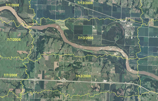
Tax collectors, tech-savvy indigenous tribes and George Clooney aren't the only ones using remote sensing and GIS applications to monitor and catch acts of criminality. There are also the crop cops at the U.S. Department of Agriculture's Aerial Photography Field Office.
Farmers may seem like trustworthy people, but the U.S. Department of Agriculture is taking no chances. It's spending tens of millions of dollars to create an enormous computerized map of every farmer's field in America. The program is intended to make sure farmers are doing what's required to earn their government subsidies.
It's an enormous task, keeping track of those subsidies. They add up to billions of dollars each year and they go to more than half a million farmers, scattered from Maine to California. Some farmers receive payments for protecting streams and wetlands; others, for growing specific crops. In each case, the payments depend on accurate information on the amount of land involved. So the USDA has resorted to a program of overhead reconnaissance — something akin of spy flights.
We mentioned this program, called the National Agriculture Imagery Program (NAIP), a couple of years ago when food prices were at record levels. Because farmers could earn more money by growing cash crops, they started converting the protective greenbelts back into croplands. In the fall of 2007, according to The New York Times, farmers “took back as many acres as are in Rhode Island and Delaware combined.”
Then came the global financial crisis of 2008, and food prices declined. But that decline, reportsGuernica, “seems to have been an anomaly.”
The December 2010 index of global food prices compiled by the U.N.’s Food and Agricultural Organization (FAO) hit a record 215, one point higher than in the spring of 2008. In fact, some food products, including sugar, cooking oils, and fats, are now trading substantially above their 2008 levels; others, including dairy products, grains, and meat, are inching perilously close to record levels.
So we'll we see more conversion of greenbelts into croplands? And will there be that one farmer who's going to keep their plump subsidies, courtesy of foreclosed and unemployed taxpayers, while plowing yet even more riches from destroyed wildlife habitats?
But what's a post without a (regurgitated) proposal: The Distributed Bureau of Agricultural Crime Investigation.
The problem with the National Agriculture Imagery Program is that there's just too many farms and too few analysts. Actually, we don't know if there are in fact too few analysts to pore through all those maps. It may be that just one cartographer is that's needed to comb through all the maps of Kansas and can do it in a couple of days.
But why not crowdsource it? Why not release the maps (that is, wikileak them, as they aren't in the public domain due to privacy matters) to the internet wilderness of distributed grid computing, data pornographers, meme-hungry social networking sites, open source virtuality and web-savvy eco-guerrillas?
It'd be like Einstein@home, a citizen science project which last year discovered a “disrupted binary pulsar” that may be the fastest-spinning of its kind. But instead of surveying the universe for distant remnants of supernovas, the teeming Web 3.0 masses use their collective clicking power to survey much nearer terrains. Imagine thousands of Google Earth addicts as citizen crop cops panning through digital screens in search of horticultural counterfeits, hours on end trying to spot cornfields where there should be reconstructed prairie or wetlands. This may even be the only time they get to interface with that other wilderness beyond the urban periphery — with Nature — for an extended amount of time.
Protecting your tax dollars while saving the environment — and enjoying the outdoors.
The Foodprint Project will truly go international on Saturday, July 31, when Sarah Rich and Nicola Twilley will head to Toronto to host the next batches of conversations about food and the city.
As a sort of preview of Foodprint Toronto, we asked the two curators a few questions about their multi-city project and the themes forming and informing the discussions.
*
Pruned: What is the Foodprint Project, and why was it started?
Nicola Twilley: The Foodprint Project is basically an exploration of the ways cities and food shape each other. So far, it's taken the form of panel discussions, one city at a time, but Sarah and I are imagining that it will gradually evolve and expand beyond that format as we go along. We launched it on January 1 this year, as a sort of shared New Year's resolution to take this interest we both have in the relationship between cities and food, and explore it in more depth by getting people with quite different perspectives together to have a public conversation about it—past, present and possible futures. The first conversation was driven by curiosity—both our own in the topic and to see whether other people would be as interested as we are — and now with the second, we're already seeing the potential to start conversations and comparisons between cities, as well as within them. So the precise what and why of Foodprint Project might expand over time—but it all comes out of a sense of the potential of using food as a lens to re-perceive, re-imagine and re-design cities.
Sarah Rich: The two key words I'd sort of add in there are design and place/space (I guess that's three words). The way we want to look at the relationship between food and cities has a lot to do with urban planning, architecture, infrastructure and the way unintentional or intentional manipulations of physical space can steer patterns of consumption and behavior.
Pruned: Many aspects of urban food systems are inextricably linked to a much wider system within an even wider system, from the regional to the national to the continental and then further on up to the inter-continentinal scale. But the project, at least in these first two iterations, is squarely focused on the city. Why this focus?
Twilley: I think a large part of the reasoning behind our city-by-city focus is for exactly the reason you describe: urban food systems are inextricably tied to a much wider system—so we can use the former as a way into the latter. In other words, we can talk about NAFTA in terms of the evolution of the Ontario Food Terminal [pdf] or corn subsidies in terms of bodega inventory. It can be really helpful to have that sort of grounded, place-specific way in to the larger discussion.
Another part of our reasoning is that most people—and more of them everyday—live in cities. Twenty-first-century urbanism is increasingly going to define and reshape our relationship with food: why not try to understand that and even flip it, to see how food could redefine twenty-first-century urbanism.
Pruned: On that last note, I'd like to tease out some of your ideas on how food should inform 21st century urbanism.
Twilley: I’m definitely interested in hearing what our panelists think about that (much more so than answering it myself!). But not to evade the question totally: I am certain food can be a helpful tool in designing and upgrading cities because it is so down-to-earth, everyday, and necessary—yet it is tied to all of the other factors we usually think about optimizing for (for example, economics, health, transportation, land-use, sustainability). So if you evaluated your designs through the lens of food (a sort of “food reality check”), then perhaps you would be sure to consider all those other important factors, in balance, and create a plan that is workable and accessible. These ideas, I should add, were originally very much inspired by architect Carolyn Steel (author of Hungry City).
Rich: In my mind, part of the big challenge around food in the 21st century is in making it a higher priority both within systems and for individuals. In schools, in hospitals, at home, in commercial zones—everywhere we go, the act of feeding ourselves is often an afterthought and the desire to spend money on food is very low. The ramifications touch education, health, tax burdens, environmental quality, the list goes on. As we think about what our cities will look like in the future, I think it's important for food to be an integral part of the conversation so that we design infrastructure and services that improve rather than degrade food systems and human health. Can bodegas manage to stock an inventory that remains relatively cheap without guaranteeing astronomical healthcare costs down the line? Can public spaces facilitate civic engagement around growing food? I think in a way this is the essential goal of Foodprint.
Pruned: Why did you choose Toronto as the next stop? I’m assuming you could have picked any city.
Rich: Toronto came in as our second stop mostly through the urgings and generous encouragement of a few of our connections there. One was Tim Maly, who writes the blog Quiet Babylon. Tim came to Foodprint NYC and he gave us a book at the end called The Edible City, published by Coach House Books, which is a collection of essays by Toronto-based writers all about food in Toronto/Ontario, approached from numerous angles. That book (as well as Food, edited by John Knechtel of Alphabet City) proved to be a great resource and a great way for Nicky and I to dive into understanding the role of food in Toronto. It was immediately clear that many people in Toronto already think about the deep connections between urbanism and food systems, so we felt like the conversations and the audience were there and we had a good opportunity to thread them together in some new ways.
We decided since Nicky and her husband, Geoff, would already be in Montreal for the summer in order for Geoff to do a research fellowship at CCA (and since Toronto's much nicer in summer than winter!), it made sense to head there.
The other early supporters of Foodprint Toronto were Mason White and Lola Sheppard of InfraNet Lab. Once we agreed to bring Foodprint to Toronto, they've all been very helpful connecting us with great people there. It should be said, we first got to know Tim and Mason via Twitter! Twitter's been a major vehicle for driving the success of this project.
Twilley: I’d just add that we always intended Foodprint Project to be an international series, so the idea of doing our second event outside of the US was especially tempting.
Pruned: The names of the panel discussions for Foodprint Toronto are the same from last time. I take it then that you'll be picking up some of the dialogues from Foodprint NYC.
Rich: I don't know that we are picking up specifically on the dialogues from Foodprint NYC, but we are threading some of the same themes and frameworks into this one. We felt it worked well to have these four, which were basically (when you take the titles away) a look at zoning/policy/economics, geography/demographics, the past and the future. These helped guide our search process as we selected panelists to invite, and they help us formulate questions that lead to distinct but complementary sessions
Twilley: I think there are some specific conversations we’ll be picking back up (two examples of questions we’ll ask in both cities, just off the top of my head: the role of different agencies in creating food policy, and the regulations governing street food vending). There are also some conversations I hope we’ll return to in different cities, but we aren’t this time (for example, the city’s foodscape as seen from other species’ point of view). Either way, our discussions will flow from the same basic questions—what can you learn about city when you map it using food as the metric? how do policy, infrastructure, and economics shape a city’s food? and so on—so there will be definitely be thematic overlap.
Pruned: Are there any new trajectories you're planning to pursue?
Twilley: There are definitely some new trajectories we'll pursue, based on the individual research interests and expertise of our panelists as well as the specificities of Toronto's urban/peri-urban context. Toronto has a green belt, for example, so we'll want to talk about that. And in Toronto, we have a First Nations fisherman joining us, so our look at food traditions can extend back some way into pre-Columbian heritage. In other cases, we'll be looking at similar themes in slightly different ways. For example, in NYC, we looked at the future of school food with Amale Androus speaking about Work AC's design for an Edible Schoolyard at P.S. 216, while in Toronto, we'll be looking at shifts in school food over the past fifty years, including the evolution of the concept of “brain food,” with historian Rebecca O'Neill.
*
Foodprint Toronto will take place on Saturday, July 31, from 12:30 to 5:00 pm, at Artscape Wychwood Barns. Here's a map.
Foodprint Toronto will be open to the public (with seating for up to 400). If you can't make it to the event, the talks will be available to view online.
Lastly, many thanks to Sarah Rich and Nicola Twilley for taking the time to answer our questions.
The eruption of Iceland's Eyjafjallajökull volcano has surprisingly led us to wonder about the prevalence of conflict flowers, those perishable symbols of beauty and romance cultivated under economic inequity and environmental exploitation.
“Farmers in Kenya are dumping tonnes of vegetables and flowers destined for the UK, four days after the volcanic ash cloud over Europe grounded cargo shipments from Africa,” reportsThe Guardian.
Kenya's flower council says the country is haemorrhaging $1.3m a day in lost shipments to Europe. Kenya normally exports up to 500 tonnes of flowers daily – 97% of which is delivered to Europe. Horticulture earned Kenya 71 billion shillings (£594m) in 2009 and is the country's top foreign exchange earner.
The flower trade may have brought much needed investment to the country, but it has also come at a cost. Like so many African countries, Kenya suffers from water scarcity, and flower farms have been blamed for exacerbating the problem through their intensive use of irrigation and pesticides. The use of chemicals has further added to the already poor working conditions. Women are discriminated, child labour is weakly discouraged, and all are paid with unfair wages.
Maybe conditions are less exploitative than how they appear to us from our distant and limited vantage point, but one has still to consider the ethical implications of cultivating vast tracts of prime arable land to produce not foods and goods for the local population but for the gas-guzzling export of what essentially amounts to lazy sentiments commodified by a multibillion dollar global guilt industry.
Perhaps for Mother's Day next month, we'll try to wean ourselves off our addiction to flower porn.
Edible Geography has another deliriously interesting post, this one on a mythological or not-so mythological tunnel in New York City through which cattle may or may not have been herded on their way from distant pastures to the slaughtering houses in the city.
Real or not, it's fascinating to speculate what might be the ideal geometry of such an underground thoroughfare for livestock. Quoting Nicola Twilley (emphasis ours):
[A]ccording to Temple Grandin, the autistic savant who is also known as “the woman who thinks like a cow,” cattle can happily walk through a tunnel—but only if it’s designed correctly. The ideal cow tunnel, she explains in her book Animals in Translation, would use indirect lighting and a non-slip floor, as well as grey or beige paint, and sound-absorbent surfaces. Any sloping sections would be single file, the tunnel should get bigger along its length in the direction of movement, and finally—fabulously—it should be curved, so that the cattle “just sort of go round and round and round like the Guggenheim Museum.”
Incidentally, we have collected quite a few CAD drawings of cattle sorting pens based on Grandin's ideal sorting program. Their serpentine design takes advantage of the cattle's circling behavior and tendency to want to go back where they came from. Moreover, it prevents the animals from seeing people and other moving objects at the end of the chute.
Splice hundreds of these units together, and you might have the basic configuration of an urban corral. Instead of a (relatively) straight tunnel with sharp turning angles, you have a tunnel smoothly weaving through New York's or some other city's subways, sewers and basement floors like a meandering stream, following perhaps the old route of a desiccated river.
Animal Architecture. With an interesting niche claimed, all it needs are more projects to post. Help them out with tips.
Delta National Park. John Bass blogs about the contested terrain of the Sacramento-San Joaquin River Delta, through which approximately 40% of water in California flows before entering San Francisco Bay and out into the Pacific. Liberally covered are aquapolitics, agriculture, hydro-infrastructure and other spatial systems, from small to large scales. Also be sure to check out the non-blog part of the site.
Subterranea Australis. One of those copy-paste blogs but we're glad it's returned after a summer hiatus, with a changed name, to copy-paste some more.
Tommy Manuel Blog. This interview with the photographer Harald Finster should help you dig in into the archives. The discussion centers on the aesthetics, documentation, preservation and rehabilitation of industrial installations.