During the height of the Cold War, anti-aircraft missile batteries surrounded many of the major population centers in the United States. Built under the Project Nike program, these rings of military bases formed defense shields against a nuclear attack from Soviet long-range bombers. At the beginning of the program, they carried missiles with conventional warheads, but in later years, they were equipped with missiles capable of carrying nuclear warheads with yields ranging from 2 to 30 kilotons.
While detonating a nuclear bomb so close to a city like Los Angeles and New York might sound like it would defeat the purpose of protecting them from such a blast, bear in mind that these Nike batteries were literally the last line of defense. Getting just a singe also seems to be a more preferable outcome than total nuclear annihilation. But exactly how many missiles were fitted with a nuclear warhead and at which sites seem to be a matter of state secret.
Chicago had a total of 23 batteries — the most among the Nike program cities. Each one was typically divided into two separate parcels of land. At the Launch Area, the missiles were stored in underground bunkers and brought up to the surface using an elevator and a rail system. Located a short distance away, the Battery Control Area contained the radar and computer equipment.
Since each site was typically manned by a large crew of at least 100 personnel, there were recreational facilities, crew quarters and other support facilities attached to either the launch or control area. Otherwise they would have been located at a separate third area.
As can be seen from the map above, most of the sites were built on the urban fringes of the city and away from densely populated areas. A couple were even located in the boondocks of northern Indiana. But what's really interesting about these Chicago emplacements (and what really piqued our interest in the very first place) is that three of them were inserted into prime parkland area along the shores of Lake Michigan.
The launch area of Site C-03, for instance, was built on Belmont Harbor; its control area was on Montrose Harbor a little further to the north. Just a few yards away from its arsenal of nuclear-capable missiles were high-rise lakefront apartments. One wonders if residents in those buildings regularly spied on the missiles preening upwards on their launchers during test runs. Surely they must have been treated to the spectacle of a simulated nuclear armageddon.
Another battery, Site C-40, was built on the northern end of Burnham Park, near McCormick Place and Soldier Field. The third, Site C-41, was located in the similarly genteel surroundings of Jackson Park, the very same park designed by Frederick Law Olmsted and Calvert Vaux and in an earlier era hosted Daniel Burnham's White City during the World's Columbian Exposition.
It's interesting to think that in the backyard of the Museum of Science of Industry, students from the nearby University of Chicago might have taken leisurely strolls among picturesque lagoons and arcadian meadows while soldiers, in their restricted enclosures, hurriedly scampered about during a readiness drill, the sounds of birds twittering and frolicking mashed up with alarms blaring. Closer to the lake, people threw frisbees around while radar towers looming above them tracked the skies for any incoming apocalypse.
All structures at the three lakefront sites have long been demolished and cleared away. Most of the other sites also have had their buildings razed and their underground bunkers filled in. Post-Nike conversions have varied through the years, and have included a police shooting range, a golf course, parking lots and industrial developments. A popular conversion seems to be turning them into “Nike Parks” or “Patriot's Parks”. There's not much left to see, in other words.
One of the better documented sites in its ruin state is C-84. Before a shopping mall was plopped down on top, the National Park Service sent some of its awesome HABS/HAER surveyors in 1992 to take some photographs. One imagines urban explorers lamenting at the loss of such a pleasure ground.
Fortunately for the dark tourists, ruin pornographers and CLUI junkies, there are still some residual traces worth your time. For instance, some concrete slabs and building foundations remain at the launcher area of Site C-44, located at Wolf Lake in the southeastern corner of the city.
To see a sizable collection of buildings and radar towers still intact, you'd have to go to Site C-47 in Indiana. The control area, now a Blast Camp paintball venue, still have some of its radar towers. All the buildings at the launcher area are still standing, though this parcel of the site is private property.
Add in a “Nike Park” and a “Patriot's Park” to the itinerary plus a stop at the C-84 shopping mall and even a picnic in Jackson Park, and you have the making of an interesting Sunday outing perambulating the city's edgelands. It'd be like re-tracing some spectral pilgrimage route encircling the city, perhaps in tangent to the same arcs and loops which decades ago some military inspector, while island hopping from one nuclear arsenal to another, had inscribed into the landscape with his irradiated body. And who knows, maybe you'll also be soaking in minute amounts of radiation at each way station, in which case your own infinitesimally irradiated body will be leaving a trail of energetic breadcrumbs.
It'll be an atomic tour of Chicago's Cold War missile defense shield.
Some photos of Irish handball alleys taken from a research blog devoted to cataloguing them and studying their histories. They're not something we were specifically searching for. In fact, we can't now remember how we came upon them, but we're glad we did. Somehow, in all that time-devouring sonic cloud of nighttime mouse clicks, we managed to discover something marvelous.
Make Use, the research group coordinating the project, writes:
The handball alley was built wherever a site was available, on parish or donated private lands, institutional lands, and often attached to lime kilns and religious ruins. The later 60x30 feet alley tended to be free standing and typically unroofed. Referred to as the ‘big’ alley, this form seems to be indigenous to Ireland and continued to be built until the introduction of the international 40x20 feet standard in 1969.
These alleys now dot the landscape. In the countryside, freestanding alleys appear like the remnants of houses and buildings abandoned by emigrants to the New World and subsequently truncated wall by wall in the years and decades ahead by those left behind: a Brutalist void-sculpture commemorating the lost generation and a nostalgic reminder of a mythic happier time before the diaspora. In cases where they are attached to buildings, they look like the remains of a former church, specifically its jutting buttressed walls, a victim of Henry VIII's Catholic pogroms, now ivy covered. Or they look like blast protection walls of an abandoned military base, a magnet for explorers of post-industrial landscapes. Or a fake ruin in a folly garden. Of course, many are actually true ruins, overgrown with shrubbery, disintegrating and inundated by the earth.
Things only get more interesting in urban areas where many of the alleys seem to have been absorbed, or accidentally adaptively reused, as the city grew around them. That side of that building or that wall or that parking lot or that space sculpted by three buildings in the back — all are actually the artifacts of codified game-spaces. Strikingly devoid of decoration, these alleys now adorn façades as archaeological ornaments.
The ruins of a medieval village above Barcelona, under 150 feet of water at the bottom of a reservoir since the 1960s, has “re-emerged into the light.”
An 11th-century church spire, entombed in the murky depths for decades, towers once again over dry ground. And that is because “in a year that so far ranks as Spain's driest since records began 60 years ago, the reservoir is currently holding as little as 18% of its capacity.” To make matters worse for the people depending on its waters, climate scientists have forecasted “still drier conditions to come in the approaching decades.”
So what other remnants of civilizations lie patiently waiting at the bottom of reservoirs to once again bath in the glow of the sun?
Or more interestingly, not ruins of villages or cities but a monstrous beast birthed by a landscape suffering from too much water, concocted in a toxic stew of asphyxiated forests, leftover sewage and drowned lives, incubated by climate change. Cloverfield in the Mist.
From the HABS/HAER collections in the Library of Congress comes these gorgeous photographs of an anti-ballistic missile complex in North Dakota.
Several such sites were planned as part of the Safeguard Program, but only this was ever completed. And after being in operations for just 4 months, it was deactivated.
In the years since, countless drunken youths and their spray paints have made pilgrimages to these Pharaonic ruins of the U.S. Army. No doubt one of them must have wondered whether if it was simply a matter of coincidence that this pyramid, whose walls he was pissing on, resembles the unfinished pyramid in the Great Seal of the United States, its once radar equipment being the Eye of Providence, the all-seeing eye.
Or if the military counts among its ranks a cabal of Freemasons constantly and surreptitiously finding ways to channel their aesthetic inclinations, in the face of institutionalized prohibition against self-expression and individuality. Sculpted berms here, geometrically-patterned rows of exhaust stacks there, mastaba-shaped radar facility right over there, chalked footpaths everywhere.
The U.S. anti-ballistic landscape as a subset of Land Art.
One of his companions, a blogger of the built environment, will later report these inebriated musings, speculating further that those anonymous soldier-bureaucrat-architects must have been great admirers of the unbuilt works of Étienne-Louis Boullée. As an homage, they designed the radar building in the form of the master's pyramidal cenotaphs.
Even their monument-complex are pierced with holes, this blogger will blog, although they are not cosmically aligned. You will not see stars; they do not form constellations. Rather, they are aligned to millions of city dwellers halfway around the world, under surveillance, targeted for total erasure.
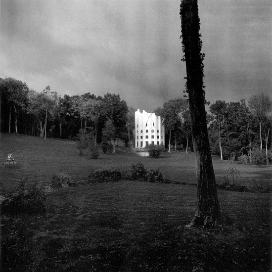
The Broken Column House is so named because it takes the form of a ruined classical column: truncated, jagged and riven with fissures. It was built by the aristocrat François Nicolas Henri Racine de Monville who used it as his main residence during the years immediately before the French Revolution. Nestled within the confines of Monville's private pleasure garden, called the Désertde Retz, it “stands like a solitary beacon, signaling the visitor to prepare for an encounter with the bizarre.”
And what bizarre encounters!
Visitors to the Désert would have encountered not just the Broken Column but also the ChineseHouse and the Tartar tent, which was made not out of fabric but tin metal, “gay with painted stripes” and erected on an artificial island in an artificial lake. Like many large gardens, it had a grotto, through which one would have entered the property (in other words, before Paradise, one must first journey down to the Abyss). There was also a peasant-chic thatched-roof cottage and the false ruins of a Gothic church. You could say, then, that the Désert was an outdoor museum of crypto-architectural history. Indeed, Diana Ketcham, in her slim but copiously illustrated book, describes it as “one of the glories of the architecture of fantasy.”
The garden itself was rather eccentric. Set within a natural-looking park were a model farm, a working dairy and an orangerie. Since Monville had no need to earn income from agriculture, these were more for leisure than production. Indeed, one shouldn't be surprised if one learns that some of Monville's guests, many of whom were members of the aristocracy, may have role-played as farmers or milkmaids for an afternoon.
Perhaps stranger things may have happened inside the walls of a garden presided over by a monied gentleman, an inveterate socialite who was said to have been “built like a model,” had “superb legs,” and bedded a different woman every night, either in the house or in any one of his fantastical follies.
One might think that Monville was psychologically unstable, the Ludwig of the Ancien Régime, and that his gardens were but the whims of one with too much money on his hands. But the Désert was a robust testing grounds for new forms and theories of landscape and architecture. Perhaps not unlike the Nevada Test Site and other military training facilities, it was an experimental terrain within which alternative systems to, say, Le Nôtre and Vitruvius, were dreamt up, cultivated and then promoted.
To a more modern visitor, meanwhile, fed with a steady diet of science fiction movies and literature, the Broken Column may evoke a distant Age of Titans, when giants roamed the land and built massive temples and homes, and the epic conflagration that ushered in the era's end, and then in the post-apocalyptic wasteland, the Lilliputian survivors made shelters out of the ruins and waited for Nature to return and erase the evidence of the disaster.
As absurd as that may sound, it is the sort of reaction Monville and other contemporary designers and patrons of irregular gardens in the English style intended to elicit. With their carefully composed views, such gardens were meant as the “stage sets for the enactment of fantasies of a pastoral or mythic character” — or “the stage for terror.”
Ketcham elaborates: “The sight of the [column] fragment generates a [...] superhuman dimension in the mind of the viewer. A corollary response is the realization that giants are at hand. Coming upon the Column, a human visitor feels the fear of the fairy tale hero stumbling up against the giant's boot.”
For the viewer who identifies with the giants, on the other hand, or with the old Testament God who struck down the Tower of Babel, the conceit of the colosal temple is exhilarating. In our unbelieving age, it is easier to respond to the purely spatial implications of the imaginary real. According to the Doric formula, height equals eight times the diameter, the full-scale column would stand at 384 feet. The architectural footprint of such a temple would extend beyond the borders of the garden.
Scale, then, becomes a technique with which Monville could create “a mood of altered reality.”
Ketcham again: “In the conventional picturesque garden, the presence of follies enhances the viewers' sense of physical and intellectual power, placing them in a controlling relation to the architecture of all times and all places, which has been scaled down to the comfortable proportions of the rural everyday landscape.” But here at the Désert, “it is the viewer who is reduced, rendered small and bewildered before the mysterious bulk of the Broken Column.”
Comparable contemporary architecture — the ones that you might expect to see in Las Vegas and RoadsideAmerica.com — may be ridden with gaudily clad tourists unknowingly suffering from post-modernist angst or architecture students, with copies of Baudrillard stuffed in their backpacks and gallons of ennui, seeking self-consciously ironic experiences.
The Désert, on the other hand, welcomed guests of a different sort. For instance, Thomas Jefferson, while serving as a minister to France, paid a visit to the Désert and “used elements of the floor plan of the the Broken Column in his design for the University of Virginia rotunda. Other illustrious persons who made it a favored retreat included Madame du Barry, the mistress of Louis XV; the Duc d'Orléans; and Queen Marie Antoinette, who found inspiration there for her English gardens at Versailles.
There are so many interesting things to be said about the Broken Column House and the Désert de Retz, but we'll limit them to two here.
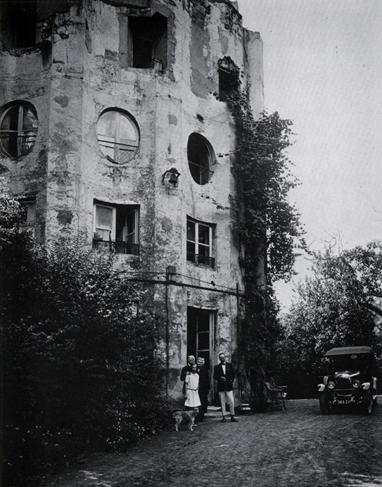
Firstly, the Désert is the only folly garden of France's eighteenth century that still exists close to its original state. Some of the grandest were leveled after the Revolution while others now exist heavily renovated or in fragments, leaving little sense of the original schemes.
But “decades of neglect saved the Désert de Retz from this common fate. Forgotten or ignored by a series of absentee owners, the park and its architectural contents were permitted to decay undisturbed and were taken up only in the 1980s as the object of restoration.”
The result is that what the eighteenth century devised as an artificial ruin became in the twentieth century a literal one, an irony whose poignancy has moved all of those who have pushed through the underbrush to enter into this forgotten place.
Secondly, as mentioned above, a program of restoration was carried out in the 1980s and one that still continues today. And therein lies some very interesting questions.
How does one return an artificial ruin, which became a true ruin, back to its original artificiality, a condition which aspired to be what it had become?
How does one restore decay from a state of real decay?
Here one imagines the restorers waking up in the middle of the night, screaming and drenched with sweat, unwilling to return to sleep for fear of dreaming recursively the horrors of authenticity. “Is this a fake crack? A real crack? Fake? Real? Fake? Real?"
In the 1940s, archaeologists discovered the ancient city of Seuthopolis, the capital seat of the Odrysian Kingdom beginning in the 4th century BCE.
Unfortunately, the discovery came too late, because under construction nearby was a reservoir dam, which would soon flood the valley and drown “the best preserved Thracian city in modern Bulgaria.”
Now over half a century later, a project proposed by Bulgarian architect Zheko Tilev would uncover and preserve the ruins using “a circular dam wall, resembling a well on the bottom of which, as on a stage, is presented the historical epic of Seuthopolis.”
Indeed, most everything about the project is theatrical: “Approaching the surrounding ring by boat from the shore Seuthopolis is completely hidden for the eye. But the view from the wall is breathtaking - with its scale, comprehensiveness and unique point of view; from the boundary between past and present. The possibility to see the city from the height of 20 meters allows the perception of its entirety.”
Once there, and if your interest in exploring archaeological sites wanes considerably faster than expected, there are other things to do on the ring-wall. For instance, there will be restaurants, cafes, shops, bike rental facilities, and also other facilities for various recreational sports and fishing.
Programmed as “a unique modern tourist complex,” the ring-wall will also house a museum, a hotel complex, open-air exhibitions, concert and festival halls, conference centers, and hanging gardens.
It's a classic case of horror vacui, in other words.
There are three sites where this should be done as well:
1) New Orleans (i.e., having abandoned the city, its inhabitants now live and work and die on grossly heightened and fattened levees; everyone will laugh at them, but when the deluge comes, they will have the last laugh)
POSTSCRIPT #1: For a different strategy than the one planned to uncover and preserve the ancient city of Seuthopolis, see the planned underwater museum of Alexandria.
These “structures” can be found off the coast of the island of Yonaguni near Okinawa, Japan, and according to the Morien Institute, they “show quite clearly that, during the last Ice Age, civilisation flourished on what were then the coastal areas of the many parts of the world which, despite glaciations further north, still enjoyed a very pleasant, temperate climate. These ancient settlements are proving to have been much more advanced urban cities than current models of prehistory are prepared to acknowledge, but their existence is just as real as the fact that they were obviously flooded during the abrupt end of the last Ice Age, at the Pleistocene/Holocene boundary.”
Or they aren't man-made structures at all, and that in actuality, according to geologist Robert M. Schoch, geomorphological processes such as “natural wave and tidal actionæ” have eroded and removed ”the sandstones in such a way that very regular step-like and terrace-like structure remain.”
Or maybe, as a middle ground between the two theories, the Yonaguni Monuments were at first natural formations but later terraformed, i.e., manipulated and modified by human hands, into ceremonial platforms.
And transoceanic ports?
Pleistocene astronomical observatories?
Or maybe it was the site of a quarry from which “blocks were cut, utilizing natural bedding, joint, and fracture planes of the rock, and thence removed for the purpose of constructing other structures which are long since gone.”
Suffice to say they require further investigation.
So in the meantime, all these photos suggest unambiguously that when the Egyptian pyramids are dropped into the bottom of the Mediterranean Sea, they will remain as enigmatic as they were in the open desert, if not more so. That any other large structures, from the Eiffel Tower to Notre Dame Cathedral to Angkor Wat, are probably better explored underwater, devoid of a totality of experience.