A cylindrical projection of Jupiter stitched together from photos taken by the Cassini spacecraft during its December 2000 flyby of the planet.
Can someone confirm for me whether or not the Army Corps of Engineers are salivating over this photo? Is it tempting them, taunting them to pack up all their trinkets — their weirs, flumes, levees, spillways, etc. &mdash and head on over to the gas giant to arrest its whorls and vortices in time and place?
The Giant Red Spot National Park. And no, it's not a dog park.
But as there really is no financial or ecological reason to be creating another national park, landscape astroengineers might just simply construct dentritic hyper-mississipian superstructures — a Jovian Theatrum Machinarum — to funnel its turbulent bands over and under, disrupting their neat parallel formation. Vortices against vortices. Cataracts against cataracts. All colliding and churning to the point when, despite falling short of critical mass and what the laws of physics might have to say otherwise, Jupiter collides in on itself and finally detonates, reborn into a star.
The Star of Fisk. The Star of Pruned? Perhaps there will be a naming competition.
This is a very old story, but it involves a perennial subject here on Pruned. Architect John Ronan apparently wants to turn Chicago's old main post office behemoth—located a mere block away from Sears Tower—into the largest municipal cemetery in the world. In Downtown Chicago!
I'm all atwitter.
Once the major processing and storage center for interstate commerce and communication, John Ronan wants to return the building to its former function, though this time to process and store something of a different sort: dead bodies — by the millions. And he sees them “floating up the Chicago River, driving down the Eisenhower, riding in on the rails.”
It's worth mentioning that Union Station and the Greyhound Station are a block away, and the Blue rail line, which connects directly to O'Hare International Airport, is even closer. In fact, it sits on top of rails, an expressway, and a subway. It could not have been better sited. The singularity of a spectral vortex. An axis mundi.
There are a lot things we like about the project. Actually, we like everything about it. Obviously at the top of the list are its location and its fidelity to the existing façade and superstructure.
Also at the top is Ronan's theatrical staging of a funeral: “A funeral barge floats silently down the Chicago River to the site where the Old Post Office once stood. A figure clad in white steps onto the river landing, and leads those gathered at the river's edge up an incline to the foot of the large, rusting steel doors. The figure knocks. A hollow echo precedes the slow opening of the doors to reveal a long hall lined on one side with chapels. The white figure leads the group to the open chapel where the ritual of life and death takes place. The rear wall of the chapel opens wide, leading the funeral party to the crypts above. Upstairs, the funeral procession winds through the glass crypts, past the reliquaries that hold souvenirs of lives now past. The reflection of candle flames flicker in the polished floor, animating the wind that passes through the open facade.”
In a lot of ways, Ronan's proposal finds close affinity with the current vogue in green burial. For instance, there are no water-guzzling grass lawns, and no lawns also means no toxic fertilizers to maintain a healthy, luxurious shade of green and to intimate a vision of Paradise to soothe grieving visitors.
Additionally, for a planned internment of millions of dead bodies, it's a highly efficient use of so little land, reusing, as it were, what's already there: “Seventy percent of what's in landfills right now is old buildings. The silliest thing would be to put a green building in its place [and] you carted away this three-million-square foot thing.”
Owing to its central location, the funeral cortege could make use of public transportation. If a CTA train car can be gutted and transformed into Santa's sleigh — with a Santa, his reindeers, elves and carollers merrily riding back and forth across Chicago, roofless(!!!) in the dead of winter — so can it be converted into a hearse.
Lastly, you can probably set the heater and air conditioner at very low levels.
“Landscapes are produced and maintained in ways that are largely unseen by those who happen to drive past, admiring the beauty of the landscape. Deeply embedded in the landscape are human costs invisible to the eye. In this paper we investigate some of the many social and material relations that underlie the pastoral views that characterize one particularly beautiful village. Bedford, a suburb of New York City, is a site of aesthetic consumption practices in which the residents derive pleasure and achieve social status by preserving and enhancing the beauty of their town. We explore the way in which the beautiful landscape of Bedford is internally related to the poor living conditions of Latino day laborers in a neighboring town, Mount Kisco. Global political and economic structures as well as the structure of local zoning, supported by a socio-spatial ideology of local autonomy and home rule, lie beneath Bedford's successful exclusion of its laborers and Mount Kisco's failure to keep out what they see as Bedford's and Latin America's 'negative externalities.' Our argument is that aesthetic concerns dominate social and economic relations between Latino immigrants and receiving communities.”
While on a recent clicker-happy run through the interweb, I stumbled upon this beautiful photo taken by Flickr user “haupthase.”
Of course, I can't resist quoting J.B. Jackson. On his time as an intelligence officer in World War II and how that experience had given him a heightened sense of environmental awareness, he writes: “the military landscape provided us with a spatial order dedicated to sudden and violent movement, a set of relationships based on total subordination and anonymity, and a sensory experience based on death and the premonition of death; it was the ugly caricature of a landscape. Nevertheless, it functioned, and even its horrors instructed us in what a good landscape, and a good social order, should be.”
In other words, to train better landscape architects, reinstitute the draft and send them off to boot camp. Embed BLA, MLA I, MLA II, and PhD candidates in combat missions, for in order to understand landscapes, one must experience how they “satisfy elementary needs,” how they “establish bonds between people, the bond of language, of manners, of the same kind of work and leisure, and how [they] should contain the kind of spatial organization which fosters such experiences and relations; spaces for coming together, to celebrate, spaces for solitude, spaces that never change and are always as memory depicted them.”
You might object, arguing 1) that you're a pacifist; 2) that you can probably acquire similar range of skills from somewhere else; and 3) that it all sounds very much like touchy-feely psychoanalytical drivel.
However, 1) landscape architecture is not a pacifist profession; 2) you can, but probably not in the very short amount of time available to you in college; and 3) the visceral, concrete quality of experience afforded by combat -- for instance, your best friend dies right in front of you, a bullet through his head, simply because someone had misinterpreted the topography, exposing the entire platoon to an ambush -- should translate into actual results, conditioning students to read landscape more critically and with keener perception.
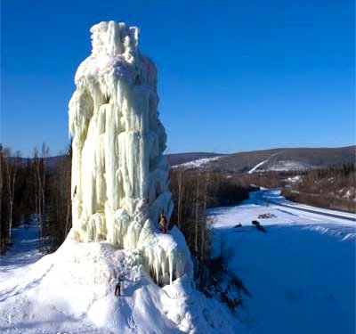
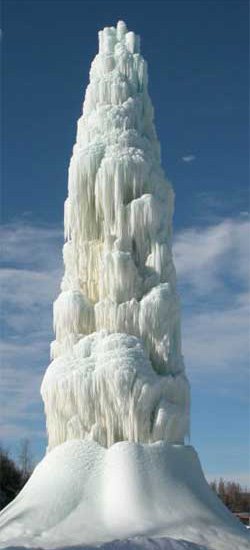
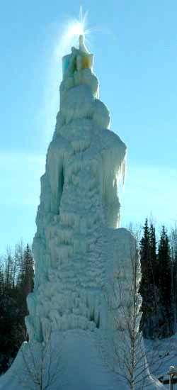
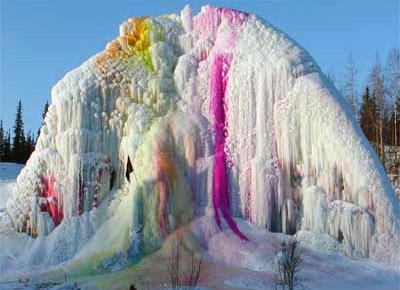
To postscript an earlier wintry post, here are some awesome icy stalagmites sculpted by members of the Alaskan Alpine Club, where one can learn all the “non-standard stuff about mountain climbing.”
Admittedly, my interest in mountain climbing goes only so far as highly recommending the documentary Touching the Void and the neglected bergfilme of Leni Riefenstahl. I simply want to learn how to construct these monoliths.
And fortunately, the instructions seem pretty straightforward: first you attach your choice of nozzle head at the end of a garden hose and then “mix random parts of water and freezing air.” Sub-zero landscape architecture in no time.
Or if you adopt their uncompromising individualist philosophy and contempt of authority: arctic guerrilla gardening.
And then there's the upcoming 2018 Chicago Winter Olympics. Expect several of these colossal frozen spires standing side by side with the city's historic skyscrapers — one of which will be the venue for an as yet nonexistent winter sport. A skyline second to none. And for the sideshow, how about a WTC-esque twin installation at the mouth of the Chicago River? The site should still be empty.
Or farther afield, ridiculously vast fields of ice towers standing as a memorial to past and future glacial ages, where you can either do some climbing or ponder the question, what is the sound of an ice tower falling in the middle of a forest of ice towers?
It's amazing that no one has yet appropriated this freezing process to create X-treme Winter Vacation Hotspots. Better but still no less safer than K2. In Antarctica or Siberia or back in Alaska.
With ike™, you can gather incredibly rich, georeferenced spatial data sets with point-and-click precision and ease. Packed inside its relatively tiny but rugged casing reside a mobile GIS with a GPS, a digital camera, a compass, an inclinometer which eliminates the need for a tripod, and a laser distance meter. The laser, in fact, also eliminates the need to be on site, allowing for data collection to be conducted from as far away as 1km. The perfect accessory for The Bleex.
In a disaster scenario, for instance, you can photograph and map out the location of breached levees, downed electricity pylons, impassable points on roads and bridges, pockets of survivors, etc., all at a safe distance, then quickly disseminated at headquarters or analyzed on the field by yourself. And the photos, hopefully, should prevent, or at least reduce, the lies and obfuscations at future congressional hearings.
All it needs then is a blog editor and a wireless internet connection. Bloggers embedded as citizen soldier-engineers in post-apocalyptic disaster zones. Reading the terrain, directing aid relief traffic.
Once, for a school project, I was tasked to delineate the border of a large waterbody in a wetland using an ancient GPS device, getting as close as possible to the water's “edge,” whether accessible or not, and shouting at frequent intervals the coordinates to my partner. This had to be done a second time, in fact, after originally misreading the “edge” entirely — only to end up with mildly accurate, incomplete data sets, which someone then painstakingly entered into ArcGIS. Suffice it to say, with ike™, the entire process would have quickly produced far more extensive and far more accurate information. And also been a lot less wet.
I wish. But in the meantime, there is the just released Busby Berkeley Collection, which packages together five of the visionary's greatest works: Footlight Parade (1933), Gold Diggers of 1933, Dames (1934), Gold Diggers of 1935, and 42nd Street (1933).
And it's got everything: dancing skyscrapers; gravity-defying pianos in deterrestrialized spaces; abstracted, disembodied, and dematerialized nubile bodies; ornamental, self-organizing crowds; Depression-era urbanism; hotels and arcadian watering holes teeming with pre-Code connubial bliss; Renaissance perspectives on acid; phantasmagorical stage sets; and a bitchless Bette Davis. You'll feel like singing and dancing afterwards. Marvelous!
A recent clicker-happy night on Flickr brought me to the incredible image above. Tom Rovers writes: “This temple is in the middle of nowhere, after you enter it's just a giant hole in the floor with stairs all arround.” Though I suspect it's not the temple proper but its stepwell, the self-similar subterranean hydrological architecture of the Subcontinent.
POSTSCRIPT #1: Title changed from Harshshat Mata. See comments.
POSTSCRIPT #2: Can we build a few of these stepwells atop the Ogllala aquifer? Robotized and with built-in AI computers, so that as the aquifer continues to be pumped dry, they would automatically dig down to follow the receding water table. Or perhaps even instinctively go in search of other aquifers. A landscape, architectural and infrastructural divining rod. And maybe centuries later, landscape architecture students on field trips can go spelunking through a karst landscape not unlike an Escher print. Of course, I would then wonder how deeply would they be willing to go? How much of the wilderness would they be able to handle?
POSTSCRIPT #3: Meanwhile, they would be the perfect venue for productions of Don Giovanni and Faust. As the opera progresses, the company slowly descends to the waters of the Styx below, one heavy, measured, ominous step at a time.
POSTSCRIPT #4: How about an avant-garde staging of Dante's Divine Comedy?
Because being wild — or even Nature, according to some — was never part of its program, Central Park had to put a stop to a coyote's sojourn within its precint. And so with reporters, photographers, and news helicopters in tow, New York policemen went on the hunt, finally capturing the intruder this morning. Of course, it would be an entirely different story if “Hal” the Coyote had settled just outside the park's boundaries.
Rest easy Frederick!
POSTSCRIPT #1: Another coyote article from The New York Times. Count 'em two! Two articles from the Times. Of course, they will soon be followed by a PBS special and then by an independent feature-length documentary directed by Werner Herzog. And finally a Hollywood sequel, Coyote Ugly II: about a girl's wild adventure in the big city, with dreams of becoming a songwriter, but one encounter with a tranquilized coyote changes all of that for the best and worst; the soundtrack will be awesome. So months go by, and a park ranger discovers another coyote who has somehow evaded detection all these time. And it's a female...with Hal's babies! An instant cult of Fauna Davidians is formed, rivaling Pale Male's own fan club. Hysterical coyote-watching day and night. Street vendors will start selling stuffed coyotes and t-shirts. A reunion of Hal with his mistress and offsprings is cooked up, and it will be televised live on The Today Show. Ratings through the roof! Madness! Madness! And Central Park, long the bastion of manufactured nature, will be decreed a wildlife sanctuary by mob rule, forever off-limits.
POSTSCRIPT #2: Or how about a new cable channel, sort of a cross between The Weather Channel and Animal Planet, providing current news reports and analysis at the intersection of human and animal cultures. A round-the-clock, real-time coverage of flu-infected birds entering Alaska, alligators on the prowl at a new Florida ex-urban development, the teaching of orphaned birdsthe ancient art of flying, pet hyenas and baboons, etc. And I would expect some of these stories, the migration of infected birds in particular, be treated like major weather events, “structured like narrative dramas with anticipation heightened by detection and tracking, leading to the climax of real-time impact, capped by the aftermath of devastation or heroic survival.”
POSTSCRIPT #3: Hal the Coyote died 30 March 2006. Cause of death: “heartworm infection and internal bleeding caused by his ingestion of rodent poison" and exacerbated by the “stress of captivity and handling during the release.” Poor fella.
POSTSCRIPT #4: There is anothercoyote on the loose in the park.
A detour upstream on the Ohio from the Mississippi brought me to Louisville, Kentucky. Google mapped above is the Great Lawn of the city's Waterfront Park designed by Hargreaves Associates. The grid meets topography meets infrastructure (soon meets OMA).
Inspired by Huck Finn and Tom Sawyer, I went for a southbound cruise on the Mississippi River. Starting from Kaskaskia, the geoannexed former state capital of Illinois, I went in search for other traces of past geopolitical skirmishes. There were many, it seems.
One certainly feels lucky to have these Mississippian provinces culturally homogeneous and politically stable. Because what would happen if a wildly meandering river forms the international boundary of two future countries who consider the other their mortal enemy? What if after a major earthquake redraws the path of this river and the capital of one gets geoannexed by the other?
Now what would happen if you designed a park on anyone of these shifting territories, and the boundaries follow the meandering course of the river, rather than fixed to an ancient silhouette. And both sides are as heterogeneous as Israel and Palestine. You've gone for a stroll one afternoon, only to find the next day that the park had migrated to the other side, where roses are considered invasive species and fountains symbolizes the excesses and economic immorality of a capitalist society. Or capital punishment is legal on one side, outlawed on the other, and public hangings have suddenly become all the rage again. Or the frontline merely bisects the park for now.
Here are some views of a terrific site specific installation, titled Flying Carpet, by the Iranian artist Seyed Alavi. It's fifty miles of the Sacramento River, or at least aerial photographs of it, woven onto a walkway bridge at Sacramento International Airport. A beautiful pairing for sure.
And then the lights come on: why not use less arcadian, more politically charged satellite images as well?
Fifty miles of the US-Mexico border fence, for instance. Or fifty miles of the San Andreas Fault coated onto an actual vehicular bridge, say, a Calatrava. Or fifty miles of Fisk's Mississippi or the future underwater trenches of the Arbonian Sea inside the corridors of the US Army Corps of Engineers. Or how about fifty miles of the Israeli security barrier inside perhaps this very brave synagogue.
Or even less as a sanctioned work of public art and more as a mode of political dissent: the bombed out shell of the al-Askari Mosque unfurled on sites heavily trafficked by Halliburton executives; the scarred landscapes surrounding an African diamond mine on the sidewalks of Antwerp's Hoveniersstraat or New York's 47th Street; the parched terrain of Mexico City during that city's ongoing 4th World Water Forum.
TerraServer appropriated as a guerilla tactic. Google Maps as acts of civil disobedience.
I can certainly imagine scenarios in which disaffected but still idealistic students in dorm rooms or co-ops or in a badly-lit cafe preparing for a rally the following day. Seated on mismatched vintage chairs, they enter long strings of longitude and latitude coordinates into TerraServer, all abstract sets of numbers but potentially worldchanging. Then a westward, eastward, northbound, southbound scopic drive all through the night in a drone of mouse clicks. Reading the landscape, strategizing with geography. Click. Click. Click. Icarus as an anarchist. And then, with their downloaded patches of terrestrial ecologies stitched together on Photoshop, they head on out to Kinko's for a late night print run, hoping against all hope that the plotters are working.
On security design: “ASLA seeks images of poor security solutions at public buildings to aid in bringing national attention to the persistent problems of security design.”
Just 24 of 101(!) low resolution mini-movies from the centerpiece installation of sLowlife, a traveling exhibition now at the US Botanical Garden. Be sure to cue the music.
Last week, occasional tipster Chris D. sent us an email that instantly put us into an uncontrollable state of giddiness. He writes:
I live in Holland which is very flat, so there's nowhere for the kids to go sledding when it snows. However, the Technical University of Delft has a library that's a sort of modern architecture grass-roofed four-story gently-sloping hill. When it snowed a week ago I took a few pictures showing the kids going crazy sledding down the library.
Also in the email were some links, including the architect's website, where we read that “the vast lawn is lifted on one edge like a sheet of paper and shapes the roof of the new library. A roof that can be walked upon. The grass roof of the library is freely accessible for walking and lounging, creating a new amenity for the whole campus.”
So perhaps not only can this building open up new multi-use strategies for urban open spaces but also, one hopes, inspire Alps-less and Rockies-less cities to create viable bids to host the Winter Olympic Games. Mt. Fuji or the Arctic Circle need not have to be nearby. A bit of artificial snow and some dramatic re-contouring of terrain, and cities unblemished by tectonic uplifts can compete with the likes of Salzburg, Sochi and Jaca.
Chicago, for instance. Here at Pruned HQ, a new Delftian library could serve as the venue for aerial and moguls freestyle skiing. Or the halfpipe.
Instead of taking a ride on ski lifts, alpine skiers will instead ride on elevators in the city's newest skyscraper up to their starting gates before slamming down on the building's sloping façades.
And rather than through a forest of Christmas trees populated by reindeers and other cute woodland creatures, cross country skiers will navigate their way through restored prairie flora and reanimated Pleistocene megafauna at Millennium Park v2.0, a new sprawling green roof covering subterranean parking garages, railyards and even the West Loop segments of the Dan Ryan, Kennedy and Eisenhower Expressways.
No doubt Chicago's Pritzker family will ask their lackey Frank Gehry to design the luge, skeleton and bobsled tracks to be sited at this new park.
And why not a hockey stadium arena atop the figure ice skating venue atop the speed skating tracks atop the Medal Ceremony Plaza right on Block 37, further densifying downtown. The Über-Loop.
In other words, the first truly urban winter olympics, one that will also please the legacy-minded IOC when it comes to post-games use.
One also hopes that the monopolistic hold on Olympic master planning by the big landscape architecture firms (Sydney/Hargreaves Associates; Beijing/Sasaki; London/EDAW) can be broken finally, allowing for mid-size and emerging studios to be hired.
Simon Norfolk's thesis is straightforward: landscape is a function of war.
In parts of London, for instance, “the Roman stones are still buried beneath the modern tarmac. Crucially, it needs to be understood that the road system built by the Romans was their highest military technology, their equivalent of the stealth bomber or the Apache helicopter - a technology that allowed a huge empire to be maintained by a relatively small army that could move quickly and safely along these paved, all-weather roads. It is extraordinary that London, a city that ought to be shaped by Tudor kings, the British Empire, Victorian engineers and modern international Finance, is a city fundamentally drawn, even to this day, by abandoned Roman military hardware.”
So not by island-making tectonics, alluvial scouring, gravitational erosion, photosynthesis, or even supernatural wizardry.
It's no surprise then that Simon Norfolk went on an enviable trip to Ascension in the South Atlantic.
Where it seems that the paradisical-sounding island is not simply an occasional lithic extension of the Earth but a gigantic surveillance machine: a weaponized island. Hardwared and networked into the global ECHELON infrastructure to eavesdrop on each and every communication of each and every person on the planet. What is spoken in the caves of Afghanistan is readily picked up in Ascension.
Certainly for some, a manufactured Fantasy Island.
I'm certainly left to wonder: which came first — the island or ECHELON?
Take equal parts Merzbau and your choice of amusement park of the American roadside vernacular variety; add a dash of Gregor Schneider for some kick and a dollop of Teletubbyland; mix all that in a Target® Michael Graves bowl; throw in one or two Richard Serra toruses if you'd like.
Designed by the artist Shusaku Arakawa and poet Madeline Gins and “[o]pened in October 1995, the Site of Reversible Destiny - Yoro Park is an 'experience park' conceived on the theme of encountering the unexpected. By guiding visitors through various unexpected experiences as they walk through its component areas, the Site offers them opportunities to rethink their physical and spiritual orientation to the world.” Can you train astronauts there?
Perhaps Virgin Galactic might require its future space tourists to log in a few hours at Yoro Park as part of their preparation in addition to visits to Baikonur. Or the now cash-strapped NASA substitute time on the centrifuge or on the vomit comet with an afternoon stroll at the Site of Reversible Destiny.
In any case, to get the most out of the park, be sure to follow the instructions, which read more like Zen koans.
Instead of being fearful of losing your balance, look forward to it (as a desirable re-ordering of the landing sites, formerly known as the senses).
Try to draw the sky down into the bowl of the field.
Use each of the five Japans to locate or to compose where you are.
If accidentally thrown completely off-balance, try to note the number, and also the type and the placement, of the landing sites essential to reconstituting a world.
Frequently swing around to look behind you.
If an area or a landing site catches your eye and attracts your interest to the same degree as the area through which you are actually moving, take it up on the spot, pursuing it as best you can as a parallel zone of activity.
Make use of the Exactitude Ridge to register each measured sequence of events that makes up the distance.
Within the Zone of the Clearest Confusion, always try to be more body and less person.
Wander through the ruin known as the Destiny House or the Landing Site Depot as though you were an extra-terrestrial.
In and about the Kinesthetic Pass, repeat every action two or three times, once in slow motion.
Meanwhile, check out more photos of the park by Liao Yusheng here. Jaunty angles, crazy scales, party colors, graphic landscaping.