During the Vietnam War, the United States flew more than 580,000 bombing missions over Laos. That's equal to one bombing mission every 8 minutes around the clock for 9 full years. In fact, the country's Xiengkhouang Province, where the famous Plain of Jars is located, is considered the most heavily bombed place on earth. This intensive bombing campaign left the landscape pockmarked with craters.
One of these craters formed mere feet away from the house of Prince Souphanouvong, later President of Laos. A trained civil engineer, he turned the hole into a kidney-shaped swimming pool, flourished with a fine biomorphic indentation.
A symbol of decadence cultivated out of hellfire and Cold War geopolitics.
While the pool may no longer be filled with water, many of these craters are permanently inundated, forming an aberrant hydrology of micro-lakes. In fact, some of them have been converted into aquafarms. Here's a photo of one of those fish ponds. In the south of neighboring, similarly pockmarked Vietnam, according to Places, “bomb craters are favored sites for houses, with a replenishable source of protein at the doorstep.”
Perhaps one day a cluster of these craters will be turned into an inverse archipelago fed by hot springs, connected together by channels, next to a luxury eco hotel, both designed perhaps by a Laotian Paisajes Emergentes, that is, a cadre of bright, enthusiastic, young tykes helping to lift their country from decades of economic strife and social conflict through design.
In any case, the Klimt-like pattern of these circular craters embedded into a tapestry of rice fields may be mesmerizing to look at, nevertheless, these aerial photos belie the fact that millions of unexploded bombs remain on the ground, all posing a deadly threat to civilians. There are still millions of silent craters waiting for that human touch.
Because there's been quite a lot of talk about the possibility of traffic disruption on the Suez Canal caused by the civil unrest in Egypt, we read up on the history of the waterway, primarily using Wikipedia, of course. In the process, we again stumbled upon the so-called Yellow Fleet, a group of 14 international vessels trapped in the canal during the Six-Day War of 1967.
After the short-lived war ended, the ships were still unable to pass through, as the canal remained closed. All ships were forced to anchor together in the Great Bitter Lake, and there they remained until the waterway was re-opened in 1975 — 8 years later!
Of course, the crews weren't trapped there during all those years, left there to fend for themselves on the border between belligerent countries. Some were allowed to go home, and relief crews were brought in. But the ships always had a crew to maintain them.
To pass the time, the fleet organized group entertainments and activities, such as card games, movie nights, football tournaments and water skiing. According to a website by Bjoern Moritz devoted to martime stamps, a year into their captivity in October 1968, the fleet organized “the ‘Bitter Lake Olympics’, coinciding with the Olympic Games in Mexico City. Crews from eight nations competed in 14 disciplines, among them fishing, sailing, acrobatic jumping and soccer. Hand crafted medals were the awards. Life boats became equipped with sailing gear, and a ‘Yacht Club’ was founded.”
We're a little disappointed not to hear of some gardening that might have gone on — of defiant gardens cultivated not for food necessarily but as a place of respite in the middle of the war and the desert.
One other activity the men on board did was making stamps by hand. Now much sought after by collectors, they weren't actual stamps. Moritz refers to them as “labels,” explaining that “[r]eal postage had to be added, either Egyptian stamps or meters. Denominations such as ‘pennies’ and ‘cents’, above, shown on some labels, were purely decorative. Yet, some covers are known to have reached their recipients ‘franked’ with the locals alone.”
Surely in a parallel world Suez Canal, the Egyptian postal service simply allowed all mails from the fleet to go through with only the homemade stamps. “Surely a few envelops aren't going to bankrupt the system,” they reasoned.
The fleet having been vested with one of the attributes of sovereignty, the captain of the Swedish ship MS Nippon, a Kurtz-like figure turned mad by the omnipresent sand — by that grit in his mouth that he wakes up to every morning, those granular bullets that constantly blitzed his eyes, that coarseness in his crotch, the protective keffiyeh he wears but overheats his polar blood, was then inspired to declare his vessel sovereign territory. Other captains followed his lead, their mental healths, too, having deteriorated not long ago. An archipelago of micronations was thus born.
The spring of 1975 came and went, but the canal remained closed. Another 8 years would pass before traffic was able to go through again, long after the owners of the ships had abandoned their costly efforts to repossess them. During that time, the President-Captains further consolidated their rule. Both Egypt and Israel were too busy with other matters to pay attention, but in the Camp David Accords, the two countries finally recognized their sovereignty.
Flash forwarded to the present through the ensuing decades of relatively prosperity fueled by boutique stamp production and Lonely Planet-toting trekkers, and there's another crisis. (For in this parallel world, conflict is also a constant.) Another Suez Canal blockade, another fleet trapped, another Bitter Lake Olympics. And more captains going unhinged from a decade of isolation, then more micronations. In another Camp David powwow, the major powers insist that Egypt cede control of the canal to the League of Suez Canal Micronations to ensure that no future conflict will again disrupt the flow of trade.
Over at Friends of the Pleistocene, they have an interview with Michael Madsen, director of Into Eternity. That film is a feature documentary on the world's first permanent nuclear waste repository, Onkalo.
“At the core of Into Eternity,” write Elizabeth Ellsworth and Jamie Kruse, “is an attempt to imagine communicating to humans hundreds of thousands of years into the future (the film is structured as an address to the future). We talked with Michael about why he chose this mode of address and how he hoped audiences of today would respond to it. We also discussed how the circumstances that necessitate the building of facilities such as Onkalo demarcate a fundamentally new chapter in human history.”
Friends of the Pleistocene: Over the course of working on this project, did you sense your own ability to project your imagination into long spans of time increase?
Michael Madsen: Well, I have to say that there is an element of the scientific disease.
While in the tunnel, I was of course looking at notes written on the walls. There are these different tracings measuring cracks and how much water is dripping in. I remember looking at it and thinking if this place is ever opened, which I think it will be, these notes will be the cave paintings of our times. But what will it mean to the persons looking at it? This was strange to think about.
Even if the cave is never marked in any sense, it will be a sign itself. The very construction will be a sign. Deep into time, even the canisters will be gone, but there will still be the scars in the bedrock. The bedrock will still have this hollow, spiral, triangular entry. There will be these symmetrical deposits of high-level or radioactive material. So, any intelligent entity in the future will be able to discern that there is symmetry in this area. Symmetry, I think, does not appear in nature as a natural phenomenon except perhaps in crystals, which are different. So any creature in the future will understand that this has been made. In this sense it will always be a sign.
To see if it's showing in a city near you, check out the schedule here.
While at Friends of the Pleistocene, also check out the first report from their recently initiated long-term project to create a typology of debris basins. Not many can arouse us more than landslide mitigation structures.
Last week Tim Malytweeted, “I live in a world where I own a machine that chimes whenever a new planet is discovered.”
But how about a machine that alerts you to an impending supernova?
There's already the Supernova Early Warning System (SNEWS), a network of five subterranean neutrino observatories, two of which we've covered here before: Super-Kamiokande and the recently completed IceCube. Neutrinos are produced in huge quantities before a massive star explodes into a supernova, and are blasted out in advance of the visible light. Since these “ghost” particles travel very close to the speed of light, they can reach us hours before we see the explosion.
The proposal here, then, is to create an app that will vibrate mobile devices when SNEWS sends out a supernova alert. Fuck making the invisible hertzian rain visible. It's just the pitter-pattering of @justinbieber's followers. Physicalize and spatialize an interstellar neutrino super-hurricane instead. Tell us when trillions and trillions and trillions of neutrinos, birthed by one of the greatest shows in the universe, are passing through us, though very rarely, if ever, does even a single one of those particles hit an atom in our body. When telescopes finally see the star's spectacular death, we hear a melodic chime.
Specifically, Greek swimming pools. We are always reminded of them now whenever we hear news of the financial crisis plaguing Eurozone member countries. Every time, without exception, news of property market bubbles, sovereign debt, IMF bailouts, governments collapsing and violent street protests, including pipe bombs set off by domestic anarchists, not only from Greece but also from Ireland, Portugal and Spain — they inevitably conjure up Suprematist images of shimmering Aegean exclaves.
This is because, as reported by Spiegel last year, Greece has been using creative ways to boost tax revenues and lessen the country's crippling government deficit. These include using Google Earth to find the swimming pools of tax cheats.
Using police helicopters, Greece's financial crimes squad “fly over Athens' affluent suburbs and make films of homes owned by doctors, lawyers and businesspeople. They use satellite pictures by Google Earth to locate country villas, swimming pools and properties. And these tactics have revealed that the suburbs didn't have 324 swimming pools, as was reported, but rather 16,974.”
...which can abruptly make a detour to George Clooney...
If you haven't already heard, the Hollywood superstar contracted malaria while on a trip to Sudan earlier this month. He was there to observe the voting for independence in Southern Sudan and to draw attention to any humanitarian abuses that might arise during and after the referendum. He has since been cured.
No doubt a far less physically taxing way to draw attention to any conflict is through another George Clooney initiative: the Satellite Sentinel project.
A collaboration between Google, the UNITAROperational Satellite Applications Programme (UNOSAT), Harvard University and celebrity-backed NGOs, the project hires private satellites to monitor signs on the ground that could indicate impending violence, such as troop buildup and movements. The images gathered by the satellites are being made public to let would-be aggressors know that the world is watching them.
“We are the anti-genocide paparazzi,” says Clooney.
...and further deviate halfway around the world to the Amazon rainforests...
Last year we read about the efforts of the Surui Indians in Brazil to protect their land reservation. “Almost three times the size of New York City,” their patch of the Amazon rainforest is constantly threatened by farmers, loggers, ranchers and gold miners from all sides. They've lost some of their forest to deforestation, but managed to save the rest.
In order to protect what's left, they've teamed up with Google to capture high resolution satellite images to better spot illegal activities on their land. Every inch of their forest will be mapped and displayed on Google Earth.
...before getting to the topic at hand: food.
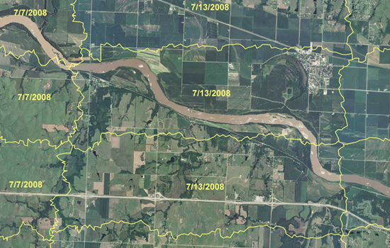
Tax collectors, tech-savvy indigenous tribes and George Clooney aren't the only ones using remote sensing and GIS applications to monitor and catch acts of criminality. There are also the crop cops at the U.S. Department of Agriculture's Aerial Photography Field Office.
Farmers may seem like trustworthy people, but the U.S. Department of Agriculture is taking no chances. It's spending tens of millions of dollars to create an enormous computerized map of every farmer's field in America. The program is intended to make sure farmers are doing what's required to earn their government subsidies.
It's an enormous task, keeping track of those subsidies. They add up to billions of dollars each year and they go to more than half a million farmers, scattered from Maine to California. Some farmers receive payments for protecting streams and wetlands; others, for growing specific crops. In each case, the payments depend on accurate information on the amount of land involved. So the USDA has resorted to a program of overhead reconnaissance — something akin of spy flights.
We mentioned this program, called the National Agriculture Imagery Program (NAIP), a couple of years ago when food prices were at record levels. Because farmers could earn more money by growing cash crops, they started converting the protective greenbelts back into croplands. In the fall of 2007, according to The New York Times, farmers “took back as many acres as are in Rhode Island and Delaware combined.”
Then came the global financial crisis of 2008, and food prices declined. But that decline, reportsGuernica, “seems to have been an anomaly.”
The December 2010 index of global food prices compiled by the U.N.’s Food and Agricultural Organization (FAO) hit a record 215, one point higher than in the spring of 2008. In fact, some food products, including sugar, cooking oils, and fats, are now trading substantially above their 2008 levels; others, including dairy products, grains, and meat, are inching perilously close to record levels.
So we'll we see more conversion of greenbelts into croplands? And will there be that one farmer who's going to keep their plump subsidies, courtesy of foreclosed and unemployed taxpayers, while plowing yet even more riches from destroyed wildlife habitats?
But what's a post without a (regurgitated) proposal: The Distributed Bureau of Agricultural Crime Investigation.
The problem with the National Agriculture Imagery Program is that there's just too many farms and too few analysts. Actually, we don't know if there are in fact too few analysts to pore through all those maps. It may be that just one cartographer is that's needed to comb through all the maps of Kansas and can do it in a couple of days.
But why not crowdsource it? Why not release the maps (that is, wikileak them, as they aren't in the public domain due to privacy matters) to the internet wilderness of distributed grid computing, data pornographers, meme-hungry social networking sites, open source virtuality and web-savvy eco-guerrillas?
It'd be like Einstein@home, a citizen science project which last year discovered a “disrupted binary pulsar” that may be the fastest-spinning of its kind. But instead of surveying the universe for distant remnants of supernovas, the teeming Web 3.0 masses use their collective clicking power to survey much nearer terrains. Imagine thousands of Google Earth addicts as citizen crop cops panning through digital screens in search of horticultural counterfeits, hours on end trying to spot cornfields where there should be reconstructed prairie or wetlands. This may even be the only time they get to interface with that other wilderness beyond the urban periphery — with Nature — for an extended amount of time.
Protecting your tax dollars while saving the environment — and enjoying the outdoors.
A forest was allowed to grow and blanket the city after its roads and parking lots were depaved, its houses and skyscrapers carted away.
While the process of ecological succession took a while, the desired climax community was reached in record time with the use of expert wilderness management strategies.
Encircling this 145,400-acre urban park is the successor city, thickly encrusted on a thin but continuous band of annexed suburban territory and sand nourished coastline. Separating the two is the new Michigan Avenue, still flower-potted and Art Nouveau-lighted but serviced with the longest subway line in the world. This grand boulevard has been tasked with the monumental job of stopping the city's sheer, vertiginous cliff-like streetwall (a mile-high in some places) from creeping into the woods.
Within are cabinets de verdure, or “rooms” cut into the woodland; the big cultural events take place here. They are all connected together by a network of allées, which are lined with topiaries of unrelentingly unvariegated design.
Beyond these formal clearings are hunting grounds, orchards, wildlife refuge areas, camping grounds and even an experimental Pleistocene Park. One can still detect the outlines and landforms of the old park system, but they're now mostly bramble patches dotted with the ruins of fountains.
All forms of dwelling are strictly prohibited, not even housing for park rangers on duty. However, the homeless and the hermits occasionally manage to avoid detection. When they are discovered, the homeless are swiftly evicted, their hovels razed to the ground. On the other hand, the hermits merely get a warning, because their authentic hermitages have become fashionable landscape accessories again.
There's the mousetrap coffee table. By placing crumbs on top, perhaps left there during a canape-laden soiree, mice are attracted to climb up the hole in its over size leg. When sensors detect that a mouse is standing on the trapdoor in the center, this door opens. The unfortunate critter then falls into a microbial fuel cell housed underneath, where it gets digested and converted into energy to power the table's electronic parts.
Two kinds of infestation battling it out here: conspicuous consumption and vermins. And since there might be hundreds of rats hiding behind the walls, we really shouldn't feel sorry for the rats decomposing in the table's innards.
Meanwhile, there's also the fly-paper clock, which is powered by insects captured on its flypaper roller and digested by its own microbial fuel cell.
Another one is the fly stealing objet d'art, which you could hang on that central space on your wall reserved for an LCD jumbotron or a flea market-bought watercolor. Like the rest, this, too, is powered by a microbial fuel cell, which churns up dead flies picked up from a web spun by its resident spiders.
One wonders if, rather than bringing spiders to it, you could just bring it to the spiders, at whichever corner of the house they may be. In other words, you'll have an excuse to rearrange or even refurnish your entire living room to match the relocated mobile. Domestic boredom feeding on itself.
One also wonders about trapping larger preys that intrude on the domestic sphere, like wildcats and alligators that regularly stumble into the backyard of houses abutting their home range. In such cases, one could turn swimming pools into carnivorous pitcher plants. When a coyote climbs down to drink from its shallow water, it closes its tarp cover and drains the water along with the animal down to its microbial fuel cell. While this pool provide a similar form of dark entertainment as its interior counterparts, it ensures a more basic domestic need: a bubble of habitability amid the wilderness. It'd be perfect for a jungle homestead.
As protection against the feral, augmented trees snatch avian flu-infected birds using their cyborg branches.